Key issues
- In the week ending 7 August 2024, low-pressure troughs and cold fronts brought rainfall across southern half of the country.
- Across cropping regions, rainfall totals of between 5 and 25 millimetres were recorded in Queensland, and up to 50 millimetres in Western Australia and the northern half of New South Wales. This rainfall will continue to support the growth and development of winter crops and pastures and help to maintain soil moisture reserves. Remaining cropping areas recorded little to no rainfall.
- Over coming days, a series of cold fronts and onshore winds are expected to bring rainfall across southern and eastern parts of the country.
- Across cropping regions, rainfall totals of up to 15 millimetres are forecast across South Australia and Queensland, and much of Victoria and New South Wales. In Western Australia, falls of between 15 and 50 millimetres are forecast for western and central areas, while eastern areas are forecast to record between 10 and 25 millimetres.
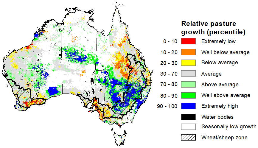
- For the 3 months to July 2024, above average rainfall totals resulted in average to extremely high pasture production across large parts of eastern and central Australia. This will likely enable farmers to maintain current stock numbers and provide opportunities to build standing dry matter availability. Below average to extremely low pasture growth rates were recorded across much of southern and eastern parts of the country. Graziers in these regions will be more reliant on supplemental feed to maintain current stocking rates and production.
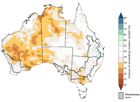
- The national rainfall outlook for September to November is a high probability of below median rainfall across the western half of the country.
- Across most cropping regions there is a roughly equal chance of receiving above or below rainfall. Higher than average rainfall is expected in parts of eastern Queensland, while below median rainfall is expected in in parts of the northern Western Australia cropping region and parts of the southeast.
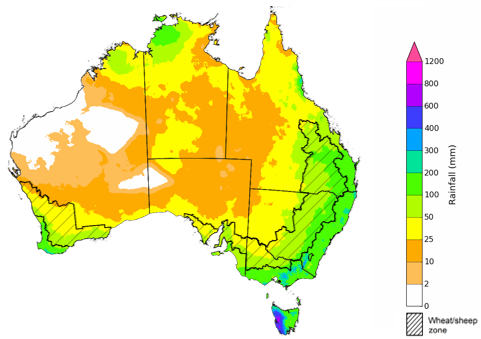
- There is 75% chance of rainfall totals being between 25 to 200 millimetres across cropping regions. If realised, these expected rainfall totals will likely be sufficient in maintaining above average winter crops yields and provide a favourable start to the summer cropping season.
- Water storage levels in the Murray-Darling Basin (MDB) increased between 1 August 2024 and 8 August 2024 by 227 gigalitres (GL). Current volume of water held in storage is 18 103 GL, equivalent to 81% of total storage capacity. This is 12% or 2,672 GL less than at the same time last year. Water storage data is sourced from the BOM.
- Allocation prices in the Victorian Murray below the Barmah Choke increased from $134 on 01 August 2024 to $142 on 8 August 2024. Prices are lower in the Murrumbidgee due to the binding of the Murrumbidgee export limit.
Climate
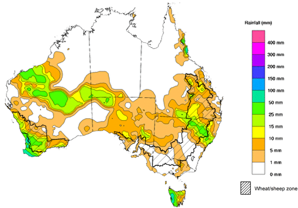
For the week ending 7 August 2024, a low-pressure trough and cold fronts brought rainfall of up to 100 millimetres to south-western Western Australia while another trough resulted in unseasonal rain of up to 50 millimetres in the states’ northwest and central areas. A cold front resulted in showers in South Australia and across Tasmania. Meanwhile, moist easterly airflow brought showers of up to 50 millimetres to Queensland's tropical coast and onshore flow resulted in up to 50 millimetres of rainfall across south-eastern Queensland and north-eastern New South Wales. High-pressure system kept much of the remainder of Australia largely dry.
Across cropping regions, rainfall totals of between 5 and 25 millimetres were recorded in Queensland, and up to 50 millimetres in Western Australia and the northern half of New South Wales. Where recorded this rainfall will continue to support the growth and development of winter crops and pastures and help to maintain soil moisture reserves. Remaining cropping areas recorded little to no rainfall.
Rainfall for the week ending 7 August 2024
Issued: 7/08/2024
Note: The rainfall analyses and associated maps utilise data contained in the Bureau of Meteorology climate database, the Australian Data Archive for Meteorology (ADAM). The analyses are initially produced automatically from real-time data with limited quality control. They are intended to provide a general overview of rainfall across Australia as quickly as possible after the observations are received. For further information go to http://www.bom.gov.au/climate/rainfall/
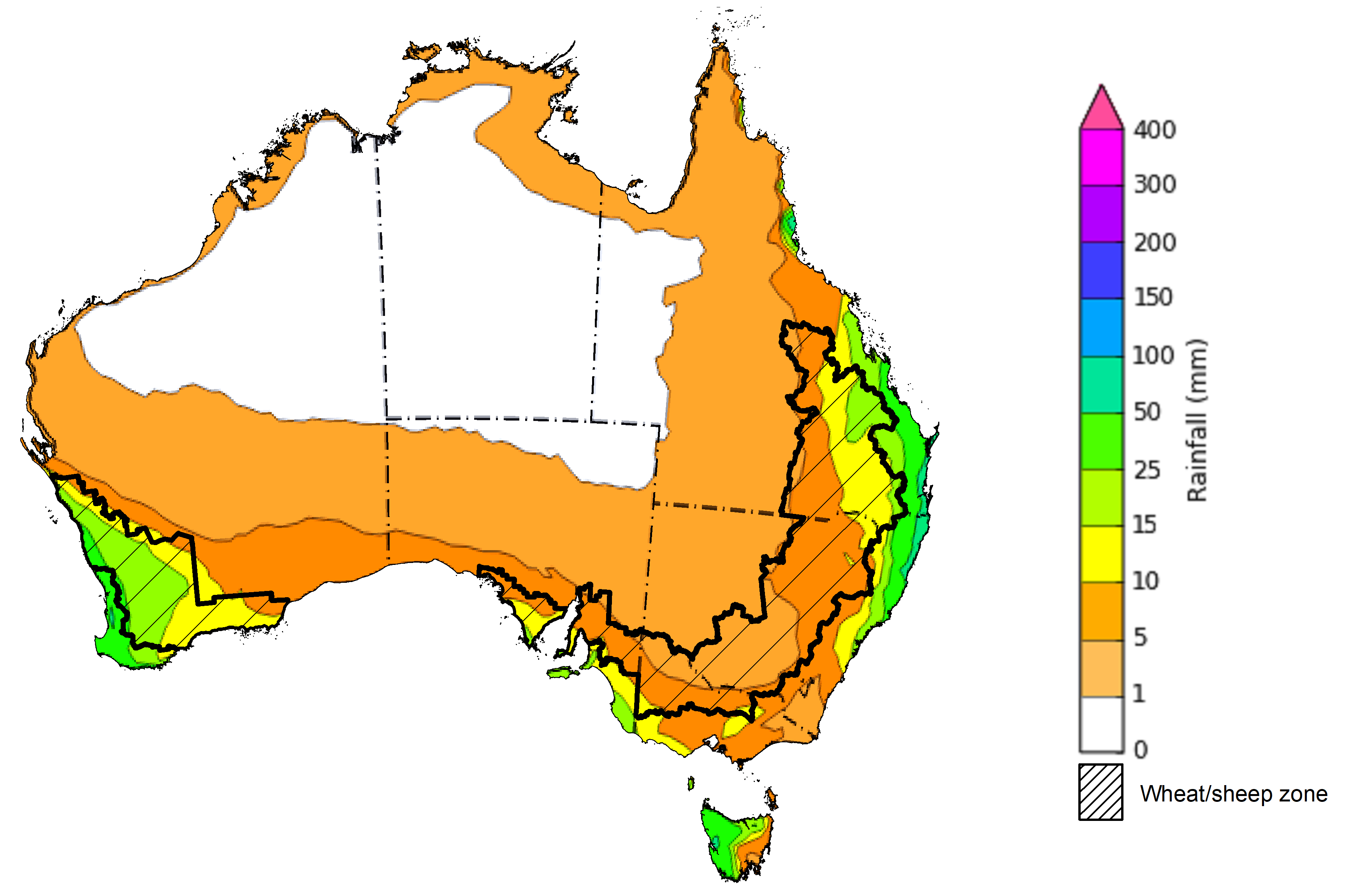
Over the 8 days to 15 August 2024, the passage of a cold front is expected to bring rainfall of up to 50 millimetres to areas of southern Australia. Onshore flow is expected to bring rainfall totals of up 100 millimetres along coastal areas of Queensland and New South Wales. Tasmania and Western Australia are forecast to receive up to 50 millimetres, while South Australia and Victoria are forecast to receive up to 15 millimetres. High-pressure systems are expected to keep the interior of the country largely dry.
Across cropping regions, rainfall totals of between 5 and 15 millimetres are forecast across South Australia and Queensland, and much of Victoria and New South Wales. In Western Australia, falls of between 15 and 50 millimetres are forecast for western and central areas, while eastern areas are forecast to record between 10 and 25 millimetres.
Total forecast rainfall for the period 8 July to 15 August 2024
Issued 08/08/2024
Note: This rainfall forecast is produced from computer models. As the model outputs are not altered by weather forecasters, it is important to check local forecasts and warnings issued by the Bureau of Meteorology.
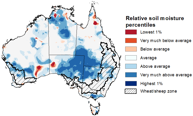
Upper layer soil moisture levels for July 2024 were mostly average to very much above average. Very much above average levels of upper layer soil moisture were modelled in South Australia, south-western Queensland and northern New South Wales, and in northern parts of the Northern Territory, as well as in southern parts of Victoria and Tasmania. Isolated areas in the Western Australia and eastern New South Wales also recorded above average soil moisture. In contrast, upper layer soil moisture was modelled to be below average in isolated areas in the Northern Territory, Queensland, Western Australia, South Australia and Tasmania.
At this time of the year, upper layer soil moisture is important for the germination and establishment of late sown winter crops across Australian cropping regions.
Across cropping regions, upper layer soil moisture in July was modelled to be generally average. Exceptions were in parts of northern New South Wales and Western Australia, as well in scattered areas across Queensland where soil moisture was very much above average. These average to above average levels of upper layer soil moisture are expected to benefit the germination and development of late and dry sown winter crops, such as in Victoria and South Australia.
Modelled upper layer soil moisture for July 2024
Source: Bureau of Meteorology (Australian Water Resources Assessment Landscape model)
Lower layer soil moisture plays a pivotal role in sustaining the growth of winter crops and pasture during their critical development stages during spring.
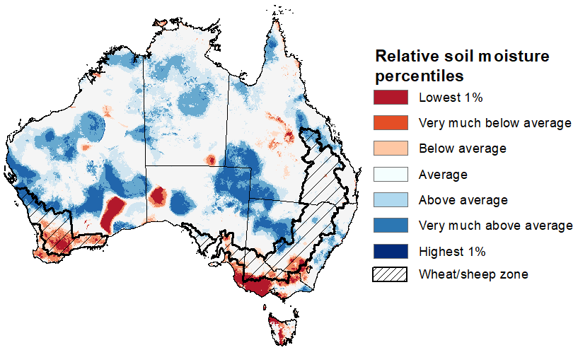
For much of Australia, the lower layer soil moisture in July was average to very much above average. In contrast, areas of extremely low lower layer soil moisture were evident across parts of southern Australia and in scattered areas in the north.
Across cropping regions, lower layer soil moisture generally ranged from average to above average in the east, except for parts of southern New South Wales and southern Victoria, and in the central areas of South Australia where it was below average. In Western Australia, lower layer soil moisture was mixed – northern cropping regions were modelled to have average to very much above average soil moisture, while southern areas had very much below average soil moisture.
In those areas currently showing extremely low to below average levels of stored soil moisture, adequate and timely rainfall will be required during the remainder of winter and spring to support the current level of forecast crop and livestock production.
Modelled lower layer soil moisture for July 2024
Source: Bureau of Meteorology (Australian Water Resources Assessment Landscape model)
During the northern Australia dry season (May to September), pasture growth typically declines significantly due to the reduction in water availability, with livestock relying on pasture grown throughout the previous wet season. During winter, pasture growth typically increases in southeast Australia, reflecting higher rainfall totals, and reduced temperatures and evapotranspiration rates at this time of year. Pasture availability during this period influences the growth and branding and marking rates of lambs and calves, livestock turnoff and the production of meat, milk, and wool.
For the 3 months to July 2024, average to extremely high pasture production relative to this time of year was recorded across large parts of eastern and central Australia, extending into central Western Australia. Despite being firmly with in the typical dry season, northern Australia also recorded generally average to above average pasture growth for this time of the year. Average to extremely high pasture production across many grazing regions will likely enable farmers to continue to maintain current stock numbers and provide opportunities to build standing dry matter availability.
In contrast, below average to extremely low pasture growth rates were recorded across large areas of southern South Australia, southern Western Australia, pasts of central Queensland and parts of western Victoria. In Tasmania, pasture growth was seasonally low, typical for this time of year. Graziers in regions where below average pasture growth was recorded will be more reliant on supplemental feed to maintain current stocking rates and production.
Relative pasture growth for 3-months ending July 2024 (1 May to 31 July 2024)
Source: Department of Environment, Science and Innovation
The El Niño Southern Oscillation (ENSO) and Indian Ocean Dipole (IOD) climate drivers are currently neutral and having minimal influence on Australian rainfall. The Southern Annular Mode (SAM) is strongly negative (as at 3 August). Forecasts indicate it is likely to remain negative for the coming fortnight. During winter, a negative SAM typically increases the likelihood of rain-bearing fronts across southern Australia and decreases rainfall in parts of the east.
The most recent rainfall outlook for September 2024 provided by the Bureau of Meteorology indicates that much of Australia has equal probability of either above or below median rainfall in September. There is an increased likelihood of above median rainfall across scattered areas in Western Australia. In contrast, there is an increased likelihood of below median rainfall across parts of northern, eastern and southern Australia.
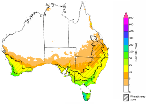
According to Bureau of Meteorology’s climate model, for September 2024 there is a 75% probability of rainfall totals between 10 and 50 millimetres across much of eastern New South Wales, Victoria, Tasmania, southern South Australia and south-western Western Australia. South-eastern Queensland is expected to receive up to 25 millimetres of rainfall. Alpine areas in New South Wales, Victoria, and the far west of Western Australia are likely receive rainfall between 100 and 200 millimetres. Tasmania is expected to receive up to 300 millimetres of rainfall in western areas. The northern and central areas of the country are expected to remain largely dry despite September typically signifying the start of the northern wet season.
Across cropping regions, there is a 75% chance of receiving between 10 and 25 millimetres of rainfall across much of New South Wales, Victoria, South Australia and Western Australia. In southern Queensland and northern New South Wales rainfall totals of between 5 and 25 millimetres are expected, while little to no rainfall is expected for northern Queensland cropping regions. Given the average to above levels of sub-soil moisture in southern Queensland and northern New South Wales, these rainfall totals are likely to be sufficient to support growth of crops.
Rainfall totals that have a 75% chance of occurring in September 2024
Issued: 08/08/2024
The rainfall outlook for September through November 2024 indicates high probability of below median rainfall in western half and parts of the southeast of the country. In contrast, above median rainfall is more likely across southeast Queensland. Remaining areas of eastern Australia have roughly equal chance of receiving above or below median rainfall.
Across cropping regions, the probability of receiving median rainfall is less than 50% in Western Australia, South Australia, Victoria and southern New South Wales. As of July 2024, many of these areas were showing below average modelled lower layer soil moisture. If above median rainfall forecast for August do not eventuate, this decreased chance of receiving above median rainfall in spring, combined with warmer than average temperatures, could be detrimental to yield determining reproductive stages of winter crop development in some regions.
Chance of exceeding the median rainfall September to November 2024
Issued: 08/08/2024
The outlook for September through to November suggests a 75% chance of rainfall totals between 25 and 200 millimetres occurring in the southern, eastern and northern parts of the country, with heavier falls of up to 600 millimetres forecast for alpine regions of Victoria and New South Wales. Western Tasmania is expected to receive falls in excess of 600 millimetres in isolated areas. Much of the remainder of the country is expected to receive little to no rainfall, typical of this time of the year.
In cropping regions, there is a 75% chance of receiving between 50 and 200 millimetres of rainfall across much of New South Wales and Queensland. In Victoria, South Australia and Western Australia, falls of between 25 and 100 millimetres are expected.
These expected rainfall totals are likely to be sufficient to support the growth and development of winter crops, boost soil moisture profile and assist in maintaining above average crops yields in most winter regions and provide a favourable start to the summer cropping season. However, a potential downside production risk exists in those regions exhibiting extremely low soil moisture levels leading into spring.
Livestock producers, especially those in the south, are expected to experience improved pasture production despite the less favourable rainfall outlook over the September to November period.
Rainfall totals that have a 75% chance of occurring September to November 2024
Issued: 08/08/2024
Water
Water storages, water markets and water allocations - current week
The Tableau dashboard may not meet accessibility requirements. For information about the contents of these dashboards contact ABARES.
Commodities
Information on weekly price changes in agricultural commodities is now available at the Weekly commodity price update.
