Key issues
- During the week ending 6 October 2021, low pressure systems dominated the Australian continent throughout much of the week, resulting in rainfall in southern and eastern parts of the country. Towards the end of the week a high-pressure system formed over South Australia and moved eastwards, bringing clear skies and dry conditions.
- For cropping regions in southern New South Wales, Victoria, South Australia and Western Australia, rainfall received this week is likely to support yield potentials, as crops progress through critical flowering and grain-fill stages. Rainfall in parts of central Queensland will support sprouting and establishment of early-sown summer crops.
- September 2021 monthly mean temperatures were around 1°C warmer than the 1961-1990 average for Australia as a whole. In contrast, mean minimum temperatures were below average to very much below average across large areas of New South Wales and southern Western Australia. The below average minimum temperatures across Western Australia were associated with widespread frost events, which are expected to negatively affect winter crop yield in that state.
- Rainfall during September 2021 was below average in south-western Australia, and average to above average across much of northern and eastern Australia. Rainfall was below average for the southern half of Western Australia, much of South Australia, and areas of eastern New South Wales and the south-east of Queensland. Rainfall was above average to well above average for most of the Northern Territory, northern Queensland, and in a band extending from south-west Queensland through central New South Wales to eastern Victoria.
- Below average rainfall through August and September across parts of South Australia and Western Australia is likely to result in lower winter crop yields than those forecast in ABARES September edition of the Australian Crop Report. Meanwhile, average or better rainfall during September across remaining winter cropping regions will help to maintain the strong yield potentials expected across these areas.
- A trough of low pressure systems and an associated cold front are expected to bring rainfall to eastern and southern Australia in the latter half of the week. The forecast rainfall is likely to support high yield potentials across parts of southern New South Wales and Victoria, as crops develop through grain filling. However, in Queensland and northern New South Wales the expected wet conditions will interrupt harvesting activities, which are already underway.
- Water storage in the Murray–Darling Basin (MDB) increased by 193 gigalitres (GL) between 26 September 2021 and 3 October 2021. The current volume of water held in storage is 21,761 GL, which represents 86% of total capacity. This is 49% or 7,164 GL more than at the same time last year.
- Allocation prices in the Victorian Murray below the Barmah Choke decreased from $125 per ML on 24 September 2021 to $114 per ML on 1 October 2021. Prices are lower in the Goulburn-Broken, Murrumbidgee, and regions above the Barmah choke due to the binding of the Goulburn intervalley trade limit, Murrumbidgee export limit, and Barmah choke trade constraint.
Climate
[expand all]
Rainfall this week
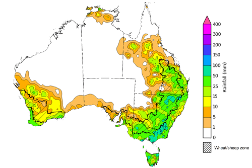
Throughout much of the week ending 6 October 2021, low pressure systems dominated the Australian continent, resulting in rainfall in southern and eastern parts of the country. Towards the end of the week, a high pressure system formed over the South Australia and moved eastwards, bringing clear skies and dry conditions.
Rainfall totals of between 10 and 50 millimetres were recorded across central and eastern New South Wales, parts of south-eastern and central Queensland, much of Victoria, the southeast of South Australia, isolated parts of south-west Western Australia and parts of Tasmania. Rainfall totals in excess of 50 millimetres were recorded across parts of north-eastern and south-western New South Wales, as well as parts of Victoria and Tasmania.
In cropping regions, rainfall totals of between 10 and 50 millimetres were recorded across much of New South Wales, Victoria and Queensland, parts of eastern South Australia, as well as parts Western Australia. Little to no rainfall was recorded in cropping regions in south-west Queensland, the west of South Australia and northern parts of Western Australia.
The rainfall across Queensland and northern New South Wales cropping regions likely interrupted harvesting of winter crops and the planting of summer crops. For some parts, near-saturated soil profiles will limit the ability for growers to access fields. For mature crops in the northern cropping regions, the rainfall over the past week will not contribute to increasing yield potentials but could negatively affect grain quality. For cropping regions in southern New South Wales, Victoria, South Australia and Western Australia, the recent rainfall likely supported yield potentials, as crops progress through critical flowering and grain-fill stages. Rainfall in parts of central Queensland will support sprouting and establishment of early-sown summer crops. Continued rainfall will boost soil moisture levels and encourage increased summer crop planting activity.
Rainfall for the week ending 6 October 2021
©Commonwealth of Australia 2021, Australian Bureau of Meteorology - Issued: 6/10/2021
Note: The rainfall analyses and associated maps utilise data contained in the Bureau of Meteorology climate database, the Australian Data Archive for Meteorology (ADAM). The analyses are initially produced automatically from real-time data with limited quality control. They are intended to provide a general overview of rainfall across Australia as quickly as possible after the observations are received. For further information go to http://www.bom.gov.au/climate/rainfall/
Monthly temperatures
September 2021 monthly mean temperatures were around 1°C warmer than the 1961-1990 average for Australia as a whole. The mean maximum temperature was 1.31°C above average, and the mean minimum temperature was 0.70°C above average.
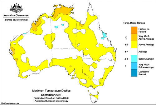
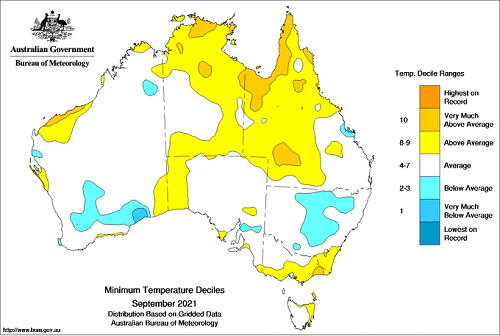
Maximum temperatures for September were very much above average for parts of northern Australia. Maximum temperatures in the remaining parts of Australia were mostly average to above average. Minimum temperatures were above average to very much above average across much of Queensland and the Northern Territory. Minimum temperatures were below average to very much below average across large areas of New South Wales and southern Western Australia. The below average minimum temperatures across Western Australia were associated with widespread frost events, which are expected to negative affect winter crop yield in that state.
Maximum temperature deciles for September 2021
©Commonwealth of Australia 2021, Australian Bureau of Meteorology - Issued: 03/10/2021
Minimum temperature deciles for September 2021
©Commonwealth of Australia 2021, Australian Bureau of Meteorology - Issued: 03/10/2021
Monthly rainfall
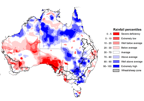
Rainfall during September 2021 was below average in south-western Australia, and average to above average across much of northern and eastern Australia. Rainfall was below average for the southern half of Western Australia, much of South Australia, and areas of eastern New South Wales and the south-east of Queensland. Rainfall was above average to well above average for most of the Northern Territory, northern Queensland, and in a band extending from south-west Queensland through central New South Wales to eastern Victoria.
The Indian Ocean Dipole (IOD) was negative for much of September, but tended toward neutral values, while the Southern Annular Mode (SAM) was positive for much of September. A negative IOD is associated with above average sea surface temperatures near Western Australia and can result in moisture-laden air moving across the continent and increasing rainfall in south-eastern Australia. At this time of year, a positive SAM usually results in above average rainfall for eastern Australia and below average rainfall for south-western regions of Australia. The weakening of the negative IOD event in September and positive SAM has contributed to below average rainfall across much of south-western Australia during September. Thunderstorm activity brought heavy falls and large hail to large areas of eastern Australia towards the end of September.
September rainfall was below average across cropping regions in much of South Australia and Western Australia. Rainfall was average to above average across most cropping regions of New South Wales, Queensland and Victoria.
Below average rainfall through August and September in South Australia and Western Australia is likely to result in lower winter crop yields than those forecast in ABARES September edition of the Australian Crop Report. These forecasts were based on the expectation of close to average to above average rainfall during September but these have not been realised. Meanwhile, average or better rainfall during September across remaining winter cropping regions will help to maintain the strong yield potentials expected across these areas.
Rainfall percentiles for September 2021
Note: Rainfall for September 2021 is compared with rainfall recorded for that period during the historical record (1900 to present). For further information, go to http://www.bom.gov.au/climate/history/rainfall/
Source: Bureau of Meteorology
Monthly soil moisture
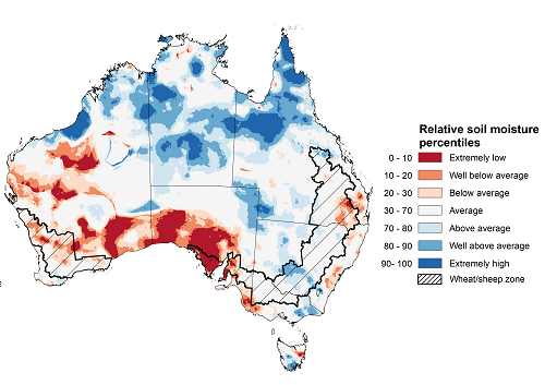
Upper layer soil moisture in September 2021 was below average for this time of year across parts of south-western and eastern Australia, following below average rainfall throughout the month. However, modelled upper layer soil moisture was above average to well above average across large parts of northern Australia, as well as isolated parts of central and south-eastern Australia.
Upper layer soil moisture across cropping regions was below average to average for this time of year in southeast Queensland, western and central South Australia and large areas of Western Australia. Upper layer soil moisture was average to above average for much of New South Wales, Victoria, remaining areas in Queensland, eastern parts of South Australia and parts of southern Western Australia. At this time of year, upper layer soil moisture is less critical for well-established winter crops. However, upper layer soil moisture will be critical for supporting the germination and establishment of summer crops in New South Wales and Queensland the coming months.
Modelled upper layer soil moisture for September 2021
Note: This map shows the levels of modelled upper layer soil moisture (0 to 10 centimetres) during September 2021. This map shows how modelled soil conditions during September 2021 compare with September conditions modelled over the reference period (1911 to 2016). Dark blue areas on the maps were much wetter in September 2021 than during the reference period. The dark red areas were much drier than during the reference period. The bulk of plant roots occur in the top 20 centimetres of the soil profile. Soil moisture in the upper layer of the soil profile is therefore useful indicator of the availability of water, particularly for germinating seed.
Source: Bureau of Meteorology (Australian Water Resources Assessment Landscape model)
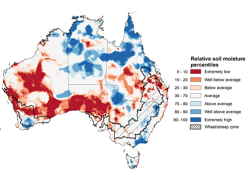
Lower layer soil moisture for September 2021 was above average for this time of year across much of northern Australia, as well as parts of western, central and south-eastern Australia. Lower layer soil moisture was below average to well below average across large areas of southern Queensland, South Australia and Western Australia.
In cropping regions, lower layer soil moisture was average to above average for parts of northern and central New South Wales, southern and northern Queensland and southern Western Australia. Lower layer soil moisture was below average to well below average in cropping regions across parts of central and western Queensland, northern and eastern Western Australia and parts of South Australia. Lower layer soil moisture is important at this time of year for winter crops as they enter flowering and grain filling during spring.
Modelled lower layer soil moisture for September 2021
Note: This map shows the levels of modelled lower layer soil moisture (10 to 100 centimetres) during September 2021. This map shows how modelled soil conditions during September 2021 compare with September conditions modelled over the reference period (1911 to 2016). Dark blue areas on the maps were much wetter in September 2021 than during the reference period. The dark red areas were much drier than during the reference period. The bulk of plant roots occur in the top 20 centimetres of the soil profile. The lower layer soil moisture is a larger, deeper store that is slower to respond to rainfall and tends to reflect accumulated rainfall events over longer time periods. Source: Bureau of Meteorology (Australian Water Resources Assessment Landscape model)
Rainfall forecast for the next eight days
A trough of low-pressure systems and an associated cold front are expected to bring rainfall to eastern and southern Australia in the latter half of the week. Clear, dry conditions are expected for the start of the week, with high pressure systems dominating southern parts of Australia and weak low-pressure troughs across the north of the country.
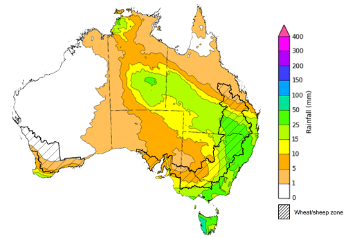
Rainfall totals of between 10 and 50 millimetres are forecast for much of eastern and central New South Wales, southern and central Queensland, southern Victoria, the south-east of the Northern Territory and eastern Tasmania, as well as isolated parts of South Australia and Western Australia. Rainfall in excess of 50 millimetres is expected in western Tasmania.
In Australian cropping regions, rainfall totals of between 10 and 50 millimetres are expected across much of New South Wales, southern and central Queensland, southern Victoria and isolated parts of South Australia. Lower rainfall totals of between 5 and 10 millimetres are expected across south-western New South Wales, northern Queensland, northern Victoria, much of South Australia, as well as southern cropping regions of Western Australia during the next 8 days.
The forecast rainfall is likely to support high yield potentials across parts of southern New South Wales and Victoria, as crops develop through grain filling. However, in Queensland and northern New South Wales the expected wet conditions will interrupt harvesting activities which are already underway. The wet conditions throughout the growing season have provided ideal conditions across eastern cropping regions thus far, but a wet finish poses a threat to grain quality. On the other hand, wet conditions will likely boost soil moisture levels in northern cropping regions as planting continues. The expectation for continued dry conditions in parts of western South Australia and eastern Western Australia will likely see further declines in yield potentials after these regions missed out on rainfall during September.
Total forecast rainfall (mm) for the period 7 October to 14 October 2021
©Commonwealth of Australia 2021, Australian Bureau of Meteorology - Issued: 6/10/2021
Note: This rainfall forecast is produced from computer models. As the model outputs are not altered by weather forecasters, it is important to check local forecasts and warnings issued by the Bureau of Meteorology.
Water
Water storages, water markets and water allocations - current week
The Tableau dashboard may not meet accessibility requirements. For information about the contents of these dashboards contact ABARES.

