
Publication date: 29 September 2021
This dataset has been superseded.
The Land tenure of Australia 2010–11 to 2015–16, 250 m is a data package of seamless continental rasters combining tenure information from state, territory, and Australian government agencies at a resolution of 250 by 250 metres. The data package contains an independent raster for each target period, a combined change raster at the most detailed classification level and a data caveat raster of known uncertainties in the product.
The land tenure datasets provide the spatial representation of the legal regime in which land is owned, leased, reserved or unallocated to a defined purpose in Australia. The datasets were constructed by combining jurisdictional land title information from digital cadastre databases or their equivalents with Indigenous land grant instruments areas. They are inputs to the first National Land Account, Experimental Estimates released jointly by the Australian Bureau of Statistics and the Department of Agriculture, Water and the Environment. They allow the reporting of tenure change between 2010–11 and 2015–16 at national, state, and regional levels.
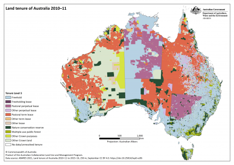
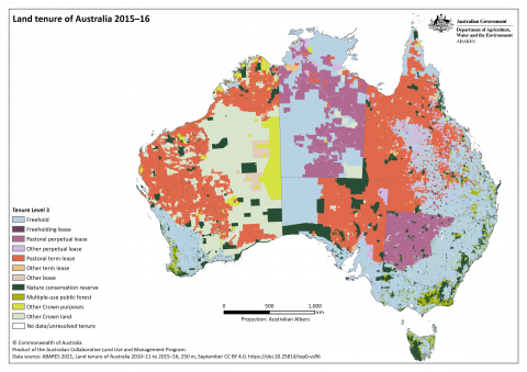
Tenure information in this dataset is classified according to a four-tiered hierarchical structure, ordered in increasing level of detail. Level 1 distinguishes between the basic land title types of freehold and Crown land. Level 2 splits Crown land into leasehold, dedicated or reserved for Crown purposes and other Crown land. Level 3 further distinguishes Crown land, defining leasehold type or Crown purposes type based on term and purpose. Leasehold types are split into freeholding lease, pastoral perpetual lease, other perpetual lease, pastoral term lease, other term lease, and other lease. Crown purposes are split into nature conservation reserve, multiple-use public forest and other Crown purposes. Level 4 distinguishes land with an Indigenous land grant, either Crown land held on behalf of, or freehold land owned by, traditional owner groups. Level 4 does not include native title which applies alongside tenure.
The Land tenure of Australia 2010–11 to 2015–16 data package is a product of the Australian Collaborative Land Use and Management Program.
Citation
ABARES 2021, Land tenure of Australia 2010–11 to 2015–16, 250 m, Australian Bureau of Agricultural and Resource Economics and Sciences, Canberra, September, CC BY 4.0. DOI: 10.25814/txp0-vs96
Downloads
The entire contents of the Land tenure of Australia 2010–11 to 2015–16, 250 m data package including spatial data, data symbology, metadata and maps is available in a single zipped package – zip [37.0 MB]
The Land tenure of Australia 2010–11 to 2015–16, 250 m data package is also available on data.gov.au.
Data
Land tenure of Australia – 2010–11 raster package (GeoTIFF and supporting files) - zip [10.9 MB]
Land tenure of Australia – 2015–16 raster package (GeoTIFF and supporting files) - zip [10.5 MB]
Land tenure of Australia – change 2010–11 to 2015–16 raster package (GeoTIFF and supporting files) - zip [14.3 MB]
Land tenure of Australia 2010–11 to 2015–16 – data caveat raster package (GeoTIFF and supporting files) - zip [4.3 MB]
Metadata
Land tenure of Australia 2010–11 to 2015–16 – descriptive metadata – MS Word [0.7 MB] and PDF [1.0 MB]
Maps
| Tenure Level 1 | 2010–11 – PNG [0.4 MB] | 2015–16 – PNG [0.4 MB] |
| Tenure Level 2 | 2010–11 – PNG [0.6 MB] | 2015–16 – PNG [0.6 MB] |
| Tenure Level 3 * | 2010–11 – PNG [0.8 MB] | 2015–16 – PNG [0.8 MB] |
| Tenure Level 4 | 2010–11 – PNG [0.8 MB] | 2015–16 – PNG [0.8 MB] |
| Tenure change Level 3 * | 2010–11 to 2015–16 Level 3 – PNG [0.1 MB] | |
| Tenure change Level 4 | 2010–11 to 2015–16 Level 4 – PNG [0.3 MB] | |
| Tenure data caveat | 2010–11 to 2015–16 – PNG [0.5 MB] | |
![2010–11 – PNG [0.4 MB]](/sites/default/files/images/tenure-l1_2010_11.png)
![2015–16 – PNG [0.4 MB]](/sites/default/files/images/tenure-l1_2015_16.png)
![2010–11 – PNG [0.6 MB]](/sites/default/files/images/tenure-l2_2010_11.png)
![2015–16 – PNG [0.6 MB]](/sites/default/files/images/tenure-l2_2015_16.png)
![2010–11 – PNG [0.8 MB]](/sites/default/files/images/tenure-l3_2010_11_update.png)
![2015–16 – PNG [0.8 MB]](/sites/default/files/images/tenure-l3_2015_16_update.png)
![2010–11 – PNG [0.8 MB]](/sites/default/files/images/tenure-l4_2010_11.png)
![2015–16 – PNG [0.8 MB]](/sites/default/files/images/tenure-l4_2015_16.png)
![2010–11 to 2015–16 Level 3 – PNG [0.1 MB]](/sites/default/files/images/tenurechange-l3_2010_11_to_2015_16.png)
![2010–11 to 2015–16 Level 4 – PNG [0.3 MB]](/sites/default/files/images/tenurechange-l4_2010_11_to_2015_16.png)
![2010–11 to 2015–16 – PNG [0.5 MB]](/sites/default/files/images/tenurecaveat_2010_11_to_2015_16.png)
* Used in the National Land Accounts, Experimental Estimates
All maps as PNG and PDF - zip [11.7 MB]
Analysis
The National Land Account, Experimental Estimates provide a physical account and change matrix at Level 3 of the tenure classification for Australia, state or territory and Statistical Areas Level 2. These tables are available on request to ABARES at the other levels of the tenure classification along with tenure flux diagrams.
Interactive views
Land tenure of Australia Web Map
Land tenure of Australia Web Services