Key issues
- In the week ending 30 October 2024, low-pressure systems and troughs brought rainfall to western, northern, and eastern areas of Australia.
- Across cropping regions, rainfall totals of between 10 and 100 millimetres were recorded in Queensland, which has likely interrupted harvest of winter crops in some areas. Little to no rainfall was recorded in southern and western cropping regions.
- Over coming days, low-pressure systems are expected to bring showers over parts of northern and eastern Australia. High-pressure systems are expected to keep remaining areas largely dry.
- Across cropping regions, some rainfall is expected across north-eastern growing regions. If realised, these moderate falls are likely to allow for the uninterrupted harvest of winter crops.
- Little to no rainfall forecast across southern Australia will provide for an uninterrupted harvest of winter crops for grain and hay where harvest has commenced. In areas which did not receive rainfall last week, farmers will be making decisions on whether to cut these crops for hay or turn them over for livestock grazing as grain yield and relative returns for grain compared to hay continue to decline.
- The northern rainfall onset, the period where the volume of rainfall needed to support plant growth occurs, for the 2024–25 season has commenced in central and northern areas of the Northern Territory and Western Australia. However, the northern rainfall onset has not yet occurred across large parts of Queensland outside of the south-east.
- Water storage levels in the Murray-Darling Basin (MDB) decreased between 24 October 2024 and 31 October 2024 by 149 gigalitres (GL). Current volume of water held in storage is 16 960 GL, equivalent to 76% of total storage capacity. This is 15 percent or 3,259GL less than at the same time last year. Water storage data is sourced from the BOM.
- Allocation prices in the Victorian Murray below the Barmah Choke increased from $134 on 24 October 2024 to $139 on 31 October 2024. Prices are lower in the Murrumbidgee due to the binding of the Murrumbidgee export limit.
Climate
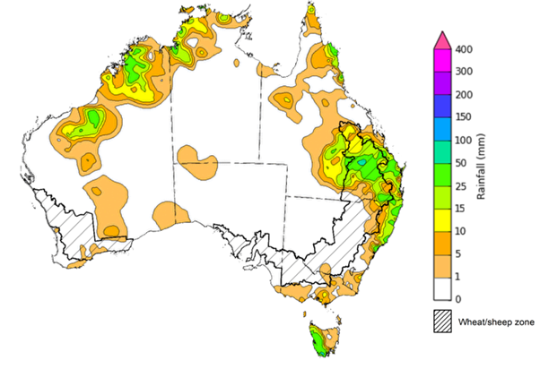
For the week ending 30 October 2024, low pressure systems and a series of troughs brought showers to parts of western, northern, and eastern Australia. Rainfall totals of up to 50 millimetres were recorded across coastal New South Wales, the northern tropics, northern Western Australia, and western Tasmania. Isolated areas of south-east Queensland recorded falls of up to 100 millimetres. High pressure systems in the south kept the remainder of the country largely dry.
Across cropping regions, little to no rainfall was recorded across most western and southern growing regions. Meanwhile, much of Queensland recorded rainfall totals between 10 to 100 millimetres. With the harvest of winter crops underway, wet conditions across much of Queensland may have interrupted harvest in some areas. Little to no rainfall across southern and western cropping regions would have allowed for a largely uninterrupted harvest of winter crops.
Rainfall for the week ending 30 October 2024

Issued: 30/10/2024
Note: The rainfall analyses and associated maps utilise data contained in the Bureau of Meteorology climate database, the Australian Data Archive for Meteorology (ADAM). The analyses are initially produced automatically from real-time data with limited quality control. They are intended to provide a general overview of rainfall across Australia as quickly as possible after the observations are received. For further information go to http://www.bom.gov.au/climate/rainfall/
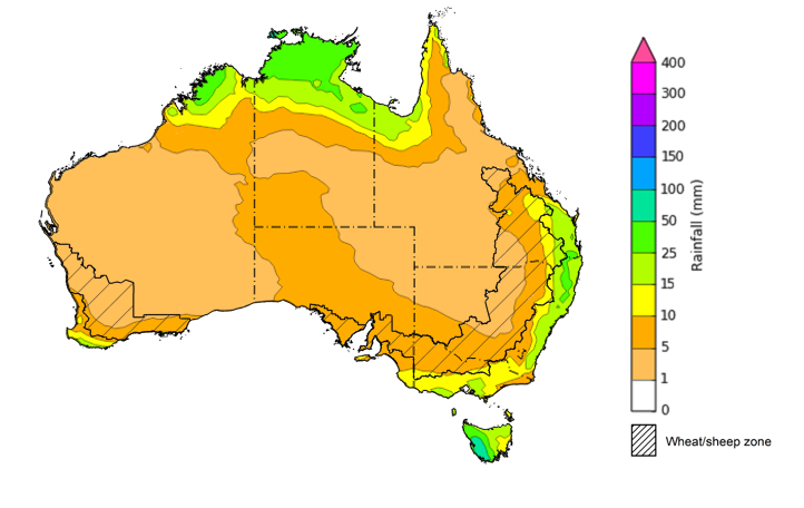
Over the 8 days to 7 November 2024, low pressure systems are expected to bring showers over parts of northern and eastern Australia. Rainfall of between 10 to 50 millimetres is expected across northern Western Australian and the Northern Territory, as well as south-eastern Queensland and eastern New South Wales. In Tasmania, rainfall totals up to 100 millimetres are forecast for parts of the west. Falls of between 5 and 25 millimetres are expected in southern areas of Victoria, South Australia and Western Australia. High pressure systems are expected to keep much of remaining areas of Australia largely dry.
Across cropping regions, little to no rainfall expected across most areas, with the exception of north-eastern growing regions where some rainfall is expected. Rainfall totals of between 5 and 25 millimetres are expected in Queensland, with eastern New South Wales and isolated areas of Victoria forecast to receive up to 15 millimetres.
If realised, these moderate falls across north-eastern cropping regions are likely to allow for an uninterrupted harvest of winter crops following a period of high rainfall in much of Queensland. Little to no rainfall forecast across southern Australia will provide for an uninterrupted harvest of winter crops for grain and hay where harvest has commenced. In areas which did not receive rainfall last week, another dry week will likely see further declines in grain yields and farmers will be making decisions on whether to cut these crops for hay or turn them over for livestock grazing as grain yield and relative returns for grain compared to hay continue to decline.
Total forecast rainfall for the period 31 October to 7 November 2024

Issued 31/10/2024
Note: This rainfall forecast is produced from computer models. As the model outputs are not altered by weather forecasters, it is important to check local forecasts and warnings issued by the Bureau of Meteorology.
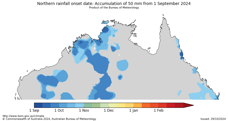
The northern rainfall onset outlook provides an indication of whether the first significant rains after the dry season are likely to be earlier or later than normal. The onset occurs when the total rainfall after 1 September reaches 50 millimetres, which is considered approximately the amount of rainfall required to stimulate plant growth. The northern rainfall onset for the 2024–25 season has commenced early in central and northern areas of the Northern Territory and Western Australia, but has not yet occurred in large parts of Queensland outside of the south-east.
Northern rainfall onset date: Accumulation of 50 mm from 1 September 2024

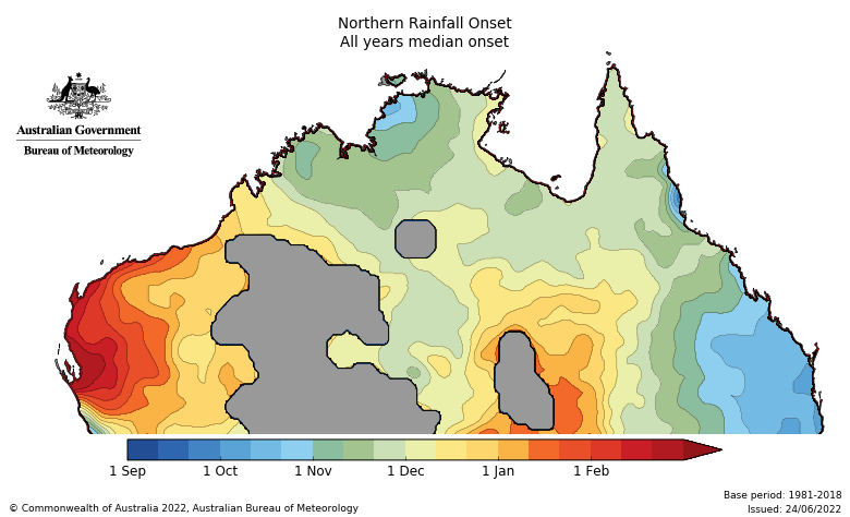
The areas of central Western Australia and the Northern Territory that have entered the northern rainfall onset do not typically experience the necessary amount of rainfall until early November to February. In contrast, the date of onset in Queensland this season is likely to be later than the historical median.
Northern rainfall onset - All years median onset

Water
Water storages, water markets and water allocations - current week
The Tableau dashboard may not meet accessibility requirements. For information about the contents of these dashboards contact ABARES.
Commodities
Information on weekly price changes in agricultural commodities is now available at the Weekly commodity price update.
