Key issues
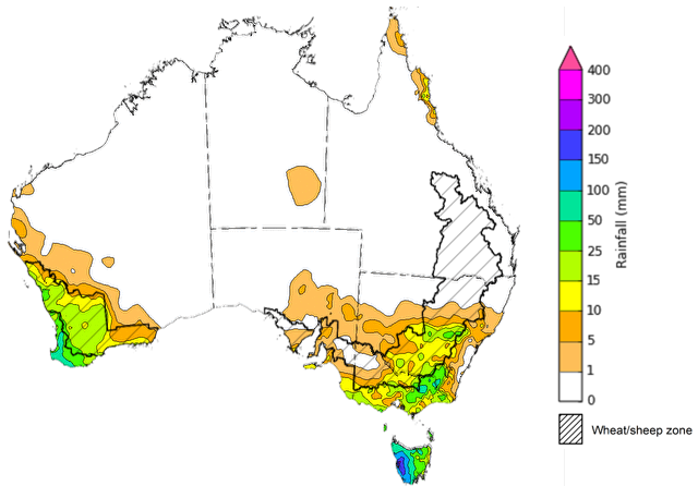
- In the week ending 28 August 2024, a high-pressure system kept much of the country mainly dry, with rainfall largely in the southwest and southeast of the country.
- Across cropping regions, rainfall totals ranging from 5 to 50 millimetres were recorded across Western Australia, central to southern New South Wales and eastern Victoria; up to 10 millimetres in parts of South Australia; while Queensland and northern New South Wales cropping regions recorded no rainfall. Where recorded, this rainfall is expected to not only support the yield prospects of winter crops, but also assist in maintaining the soil moisture reserves particularly in southern Western Australia and central New South Wales.
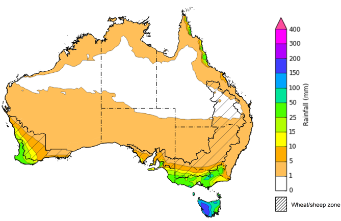
- Over coming days, cold fronts are expected to bring a cold change with showers to the south-west and south-east of Australia, including Tasmania. High-pressure systems are expected to keep the central and northern parts of the country largely dry.
- Across cropping regions, rainfall totals of between 5 and 25 millimetres are forecast across Western Australia. Victoria is expected to receive up to 50 millimetres of rainfall, with much of South Australia forecast to receive between 5 and 10 millimetres. If realised, this rainfall is expected to support the growth of crops and pastures in southern regions, with crops in New South Wales and Queensland to draw on stored soil moisture to support growth.
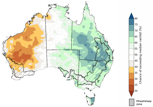
- The national rainfall outlook for Spring 2024 indicated an increased probability of above median rainfall across eastern central areas of the country. However, much of Western Australia, and northwestern areas in the Northern Territory are more likely to receive below median rainfall, with the probability below 40% of exceeding median rain.
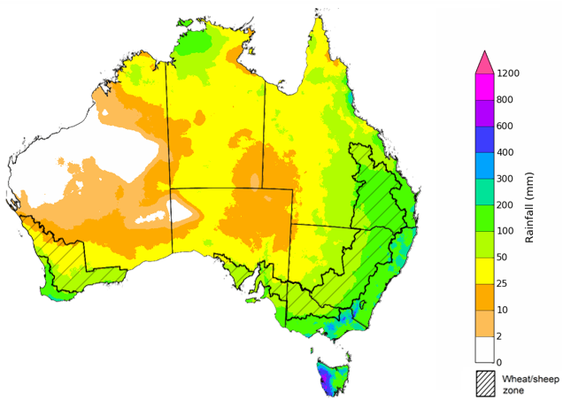
- There is at least a 75% chance of receiving between 50 and 200 millimetres of rainfall across Queensland and New South Wales, and between 25 and 100 millimetres in the remaining states. If realised, these expected rainfall totals will likely be sufficient to support the flowering and grain filling stages of winter crop development, boost soil moisture profiles, assist in maintaining current winter crop yield expectations in most regions and provide a favourable start to the summer cropping season.
- Water storage levels in the Murray-Darling Basin (MDB) increased between 22 August 2024 by 75 gigalitres (GL). Current volume of water held in storage is 18 390 GL, equivalent to 83% of total storage capacity. This is 10% or 2,495GL less than at the same time last year. Water storage data is sourced from the BOM.
- Allocation prices in the Victorian Murray below the Barmah Choke decreased from $148 on 22 August 2024 to $147 on 29 August 2024. Prices are lower in the Murrumbidgee due to the binding of the Murrumbidgee export limit.
Climate
For the week ending 28 August 2024, a high-pressure system kept much of the country mainly dry. Several weather systems moved through south-west Western Australia and Tasmania, bringing widespread light to moderate rainfall, with localised heavy falls. A strong cold front swept through southeastern Australia, bringing severe thunderstorms across parts of Victoria and southern New South Wales, resulting in rainfall totals of between 10 to 100 millimetres.
Across cropping regions, rainfall totals ranging from 5 to 50 millimetres were recorded across Western Australia, central to southern New South Wales and eastern Victoria. Falls of up to 10 millimetres were recorded in parts of South Australia, while Queensland and northern New South Wales cropping regions recorded no rainfall. Where recorded, this rainfall is expected to not only support the yield prospects of winter crops, but also assist in maintaining the soil moisture reserves particularly in southern Western Australia and central New South Wales. Little to no rainfall across northern New South Wales and Queensland is expected to contribute to a drawdown of soil moisture, as crops utilised average to above average levels of stored soil moisture to maintain current yield potentials.
Rainfall for the week ending 28 August 2024
Over the 8 days to 5 September 2024, cold fronts are expected to bring a cold change with showers to the south-west and south-east of Australia, including Tasmania. High-pressure systems are expected to keep the central and northern parts of the country largely dry.
Across cropping regions, rainfall totals of between 5 and 25 millimetres are forecast across Western Australia, with higher rainfall totals in the far south-western regions. Meanwhile, Victoria is expected to receive up to 50 millimetres of rainfall, with much of South Australia forecast to receive between 5 and 10 millimetres. Little to no rainfall is forecast for New South Wales and Queensland cropping regions, with a maximum of 5 millimetres of rainfall. If realised, this rainfall is expected to support the growth of crops and pastures in southern regions, with crops in New South Wales and Queensland to draw on stored soil moisture to support growth.
Total forecast rainfall for the period 29 August to 5 September 2024
Frost occurs on clear nights during the late autumn to early spring period, when the air temperature drops to 2°C or lower and is most pronounced in the southern and eastern agricultural regions. The weather events that typically generate damaging frosts are from the passage of cold fronts, followed by cold southerly winds and a high-pressure ridge. The severity and extent of subsequent damage is variable across the landscape. Crop damage from frost may occur at any stage of development but is most damaging around flowering and grain filling in spring. During the early stages of plant growth, frost can damage emerging crop.
Severe frosts (minimum temperatures below -2°C) can cause freezing damage to a crop when there is rapid ice crystal formation form within the tissue. The ice crystals physically rupture cell walls and membranes within the cells. Damage can be seen once thawed as dark green water-soaked areas. Ten days after a frost event, bleached leaves, stems and reproductive tissue might be evident depending on the growth stage of the crop.
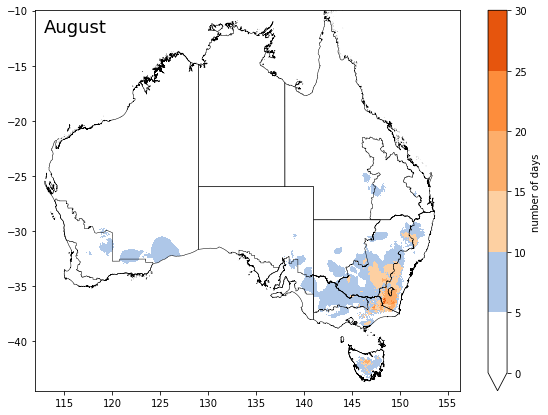
During between 1 August and 28 August 2024, cropping regions across much of Victoria and southern New South Wales and parts of western Queensland, eastern South Australia and eastern Western Australia experienced at least 10 frost events. Central and northeastern areas in New South Wales recorded up to 15 frost events. Depending on the growth stage of crops and the severity and length of time crops were subjected to frost, this presents a localised risk to crop production in these areas.
Number of days with minimum temperature below 2°C in August 2024
The most recent rainfall outlook for September 2024 provided by the Bureau of Meteorology indicates an increased likelihood of above median rainfall across eastern half of the country, including Tasmania. In contrast, there is an increased likelihood of below median rainfall across Western Australia.
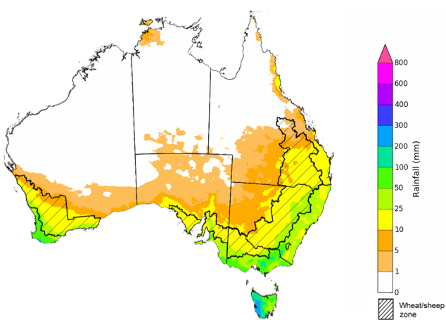
According to Bureau of Meteorology’s climate model, for September 2024 there is a 75% probability of rainfall totals between 10 and 100 millimetres across eastern New South Wales, Victoria, and southern areas of Western Australia and South Australia. South-eastern Queensland is expected to receive up to 25 millimetres of rainfall. Alpine areas in New South Wales and Victoria will likely receive rainfall of up to 200 millimetres. Tasmania is expected to receive up to 300 millimetres of rainfall. The northern areas of the country are expected to remain largely dry.
Across cropping regions, there is a 75% chance of receiving between 10 and 50 millimetres of rainfall in New South Wales, Victoria, South Australia and Western Australia. If realised, these rainfall totals are likely to be sufficient to support growth of crops through September. In Queensland, rainfall totals of between 5 and 25 millimetres are expected across southern cropping regions, while little to no rainfall is expected for northern cropping regions. This expected lack of rainfall in the central to northern areas is unlikely to negatively impact winter crop development, due to above average levels of stored soil moisture maintain current yield potentials.
Rainfall totals that have a 75% chance of occurring in September 2024
The El Niño Southern Oscillation (ENSO) and Indian Ocean Dipole (IOD) climate drivers are currently neutral and having minimal influence on Australian rainfall.
The rainfall outlook for September through November 2024 indicates that above median rainfall is more likely across eastern and central areas of the country. In contrast, much of Western Australia, and northwestern areas in the Northern Territory are more likely to receive below median rainfall, with the probability below 40% of exceeding median rain in these areas. Remaining areas have equal chance of receiving above or below median rainfall.
Across cropping regions, the probability of exceeding median rainfall is between 60% and 75% in Queensland and New South Wales and parts of South Australia. The chance of above median in the most of South Australia and Victoria is between 50% and 65%. By contrast, the outlook for Western Australia is for below median rainfall in the northern half of the cropping regions and an equal chance of either above or below median rainfall in southern half. If realised, this rainfall would support ABARES forecasts of above average winter crop yields in New South Wales and Queensland, and help support current yield expectations in Victoria, South Australia and Western Australia. The buildup of soil moisture from rainfall in northern New South Wales and Queensland will also prepare for an ideal start to the summer cropping season.
Chance of exceeding the median rainfall September to November 2024
Note: The world precipitation percentiles indicate a ranking of precipitation for March, with the driest (0th percentile) being 0 on the scale and the wettest (100th percentile) being 1 on the scale. Percentiles are based on precipitation estimates from the NOAA Climate Prediction Center’s Climate Anomaly Monitoring System Outgoing Precipitation Index dataset. Precipitation estimates for April 2024 are compared with rainfall recorded for that period during the 1981 to 2010 base period. Source: International Research Institute for Climate and Society
The outlook for September through to November suggests a 75% chance of rainfall totals between 25 and 200 millimetres occurring in the eastern, southern and northern part of the country, with heavier falls of up to 600 millimetres forecast for alpine regions of Victoria and New South Wales. Western Tasmania is expected to receive falls in excess of 600 millimetres.
In cropping regions, there is at least a 75% chance of receiving between 50 and 200 millimetres of rainfall across much of New South Wales, Queensland and Victoria, and between 25 and 100 millimetres in South Australia and Western Australia.
These expected rainfall totals are likely to be sufficient to support the flowering and grain filling stages of winter crop development, boost soil moisture profile, assist in maintaining current winter crop yield expectations in most regions and provide a favourable start to the summer cropping season.
Livestock producers, especially those in the south and east of the country, are expected to experience close to average pasture production on the back of the improving rainfall outlook over the spring season.
Rainfall totals that have a 75% chance of occurring September to November 2024
The northern rainfall onset outlook provides an indication of whether the first significant rains after the dry season are likely to be earlier or later than normal. The onset occurs when the total rainfall after 1 September reaches 50 millimetres, which is considered approximately the amount of rainfall required to stimulate plant growth. The northern rainfall onset for the 2024–25 season is likely to be later than usual for most of the western parts of northern Australia, but earlier for parts of the east. Much of Western Australia have a 60–70% chance of a later than usual northern rainfall onset. Across Queensland and Top End of Northern Territory, the rainfall onset is likely (60–75%) to be earlier than usual. These odds have increased in the last fortnight. Elsewhere, the northern rainfall onset is likely to be closer to the normal onset date.
Chance of early Northern Rainfall Onset
![Map showing the likelihood of early Northern Australia Rainfall Onset. Later than usual rainfall onset likely in the west and central regions, earlier in parts of the east.]](/sites/default/files/images/20240829.nro_.forecast.mr_.png)
Water
Water storages, water markets and water allocations - current week
The Tableau dashboard may not meet accessibility requirements. For information about the contents of these dashboards contact ABARES.
Commodities
Information on weekly price changes in agricultural commodities is now available at the Weekly commodity price update.
