Key issues
- For the week ending 23 August 2023, frontal systems and a trough brought showers to southern parts of Australia. Up to 50 millimetres of rainfall was recorded in parts of Western Australia, eastern New South Wales and in western Tasmania. A high-pressure system kept the remainder of the country dry and clear.
- Across cropping regions, rainfall totals of up to 25 millimetres were recorded in central New South Wales and southern and central parts of Western Australia. Little to no rainfall was recorded in the remaining cropping regions and these regions will require sufficient and timely rain in the coming weeks and months to maintain current levels of winter crop production, following a gradual decline in soil moisture reserves (see Section 1.1).
- Drier than normal conditions are expected in September for large areas of Australia. Across cropping regions, during September there is a there is a 75% chance of rainfall totals of between 10 and 25 millimetres across eastern New South Wales, southern and central Victoria, western and central South Australia and western and southern Western Australia. If realised, this poor September 2023 rainfall outlook represents a significant downside production risk for both winter and summer crop production as well as pasture growth (see Section 1.2).
- During September to November 2023, there is 75% chance of receiving between 25 and 100 millimetres across most winter cropping regions, except for northern cropping regions in Western Australia where falls are expected to be below 25 millimetres. If realised, these falls may be sufficient to support close to average plant growth, in areas with average or better levels of soil moisture. In areas with low soil moisture, such as southern Queensland, north-western New South Wales and northern and eastern Western Australia, these probable low three-month rainfall totals are unlikely to be sufficient to sustain average levels of crop and pasture production (see Section 1.2).
- On 23 August 2023, the Australasian Fire and Emergency Services Authorities Council (AFAC) released its Seasonal Bushfire Outlook for spring 2023. An increased risk of fire is expected for large areas of New South Wales, Queensland and the Northern Territory, as well as parts of Victoria and South Australia. This increased risk of bushfires represents a significant localised risk to crop and livestock (see Section 1.3).
- Over the 8-days to 31 August 2023, fronts and troughs are expected to bring isolated showers to south-eastern parts of the country. Across cropping regions, minimal rainfall totals of up to 5 millimetres are expected across much of New South Wales and Queensland, in central South Australia and southern Western Australia. No rainfall is expected remaining areas. These falls are likely to be of little benefit to crops and pastures as they are unlikely to be sufficient to offset evaporative losses (see Section 1.4).
- Water storage levels in the Murray-Darling Basin (MDB) increased between 17 August 2023 and 24 August 2023 by 34 gigalitres (GL). Current volume of water held in storage is 20 983 GL. This is 2 percent or 507 GL less than at the same time last year.
- Allocation prices in the Victorian Murray below the Barmah Choke increased from $152 on 10 August 2023 to $155 on 17 August 2023. Prices are lower in regions above the Barmah choke due to the binding of the Barmah choke trade constraint.
Climate
For the week ending 23 August 2023, frontal systems and a trough brought showers to parts of southern Australia. Up to 50 millimetres of rainfall was recorded in parts of eastern and southern New South Wales, southern South Australia, much of Victoria and western Tasmania. A high-pressure system kept the remainder of the country dry and clear.
Across cropping regions, rainfall totals of up to 25 millimetres were recorded in south-eastern New South Wales, western and eastern Victoria and across much of South Australia. Little to no rainfall was recorded in the remaining cropping regions and these regions will require sufficient and timely rain in the coming weeks and months to maintain current levels of winter crop production, following a gradual decline in soil moisture reserves.
Rainfall for the week ending 23 August 2023
Note: The rainfall analyses and associated maps utilise data contained in the Bureau of Meteorology climate database, the Australian Data Archive for Meteorology (ADAM). The analyses are initially produced automatically from real-time data with limited quality control. They are intended to provide a general overview of rainfall across Australia as quickly as possible after the observations are received. For further information go to http://www.bom.gov.au/climate/rainfall/
These climate outlooks are generated by ACCESS–S (Australian Community Climate Earth-System Simulator–Seasonal). ACCESS–S is the Bureau of Meteorology's dynamic (physics-based) weather and climate model used for monthly, seasonal, and longer-lead climate outlooks. For further information, go to http://www.bom.gov.au/climate/ahead/about/.
The Bureau of Meteorology’s latest rainfall outlook for September 2023 indicates drier than average conditions are expected across large areas of northern, eastern and southern Australia.
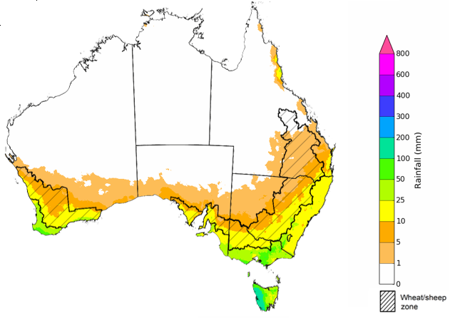
The ACCESS-S climate model suggests that there is a 75% chance of rainfall totals between 10 and 50 millimetres across eastern New South Wales, scattered areas of coastal Queensland, much of Victoria and Tasmania, southern South Australia, and southwest Western Australia. Rainfall totals in excess of 100 millimetres are expected across western Tasmania and far southwest Western Australia.
Across cropping regions, there is a 75% chance of rainfall totals of between 10 and 25 millimetres across eastern New South Wales, southern and central Victoria, western and central South Australia and western and southern Western Australia. September rainfall totals are expected to be below 10 millimetres for cropping regions in northern New South Wales, Queensland and eastern Western Australia.
If realised, this poor September 2023 rainfall outlook for Queensland, northern and western New South Wales and northern Western Australia represent a significant downside production risk for both winter and summer crop production as well as pasture growth, particularly given the lack of August rainfall and well below average soil moisture levels in these areas.
Rainfall totals that have a 75% chance of occurring in September 2023
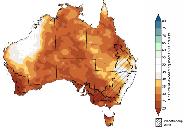
The rainfall outlook for September to November 2023 suggests that there is close to equal chances of above or below median rainfall for the northwest of Western Australia, coastal New South Wales, and parts south-eastern Queensland. However, below median rainfall is more likely in across remaining areas.
Across cropping regions, below median rainfall is more likely for most areas through the September to November period, except for parts of northern New South Wales and south-eastern Queensland where this not strong tendency towards above or below median rainfall.
Chance of exceeding the median rainfall September to November 2023
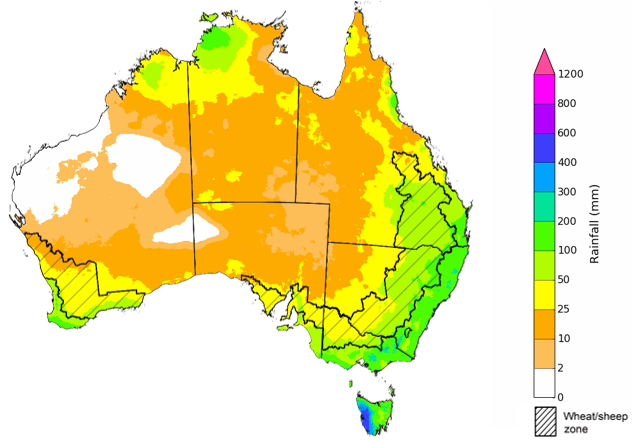
The outlook for September to November 2023 suggests there is a 75% chance of rainfall totals between 25 and 100 millimetres across much of New South Wales, Victoria and Tasmania, parts of south-eastern and coastal Queensland, and southern parts of South Australia and Western Australia, and parts of northern Northern Territory. Rainfall totals in excess of 200 millimetres are forecast for alpine regions of Victoria and New South Wales and western Tasmania.
There is a 75% chance of receiving between 25 and 100 millimetres across most winter cropping regions, except for northern cropping regions in Western Australia where falls are expected to be below 25 millimetres. If realised these falls may be sufficient to support close to average plant growth, in areas with average or better levels of soil moisture.
However, in areas with low soil moisture, such as southern Queensland, north-western New South Wales and northern and eastern Western Australia these probable low three-month rainfall totals are unlikely to be sufficient to sustain average levels of crop and pasture production. Particularly as we enter the early months of spring, with higher temperatures and increased water demand for crops and pastures.
Rainfall totals that have a 75% chance of occurring September to November 2023
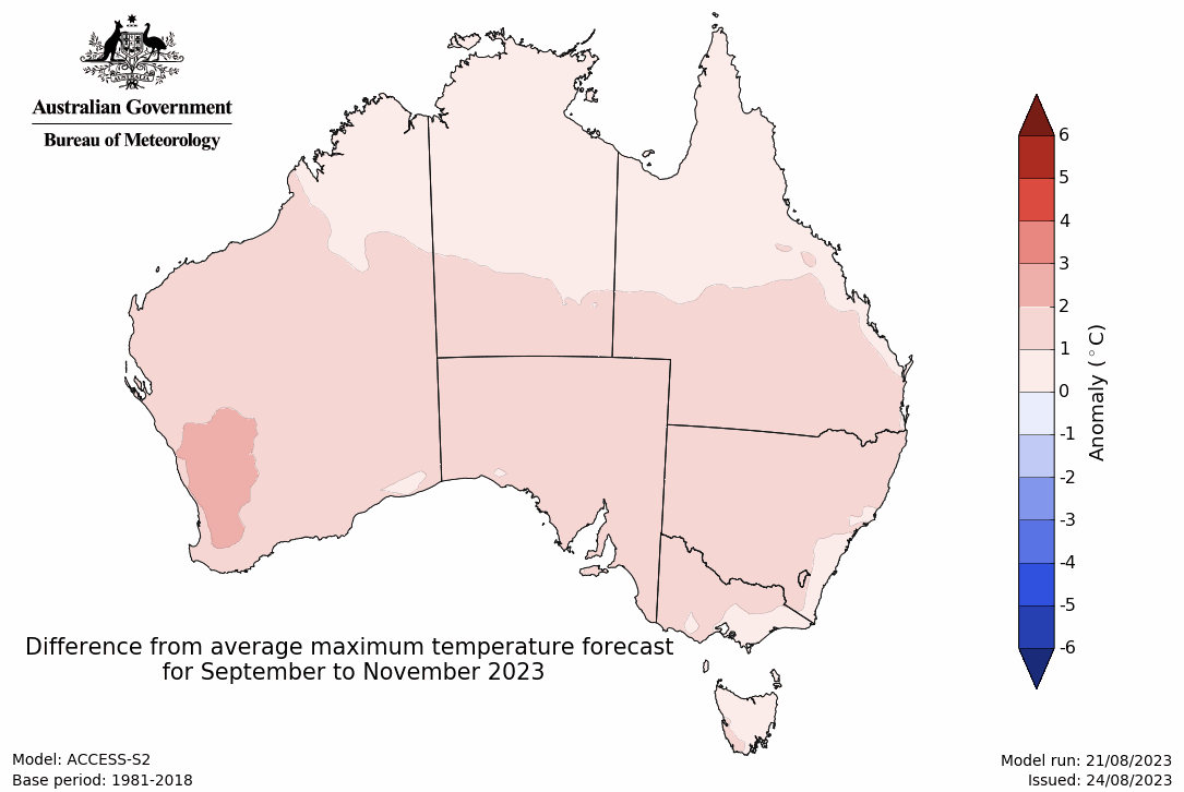
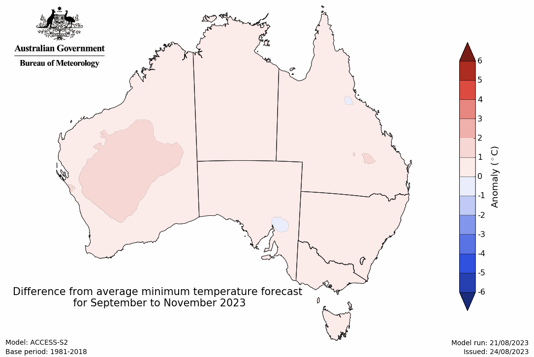
The temperature outlook for September to November 2023 indicates that maximum temperatures across northern Australia, parts of south-eastern New South Wales and Victoria, and Tasmania are likely to be close to the 1990–2012 average (-1°C to +1°C). Meanwhile maximum temperatures are expected to be warmer than average (above +1°C) across much of the remainder of southern Australia. Minimum temperatures are expected to be close to the 1990–2012 average (-1°C to +1°C) across most of Australia. The night-time temperatures in central parts of Western Australia are likely to be warmer that average (above +1°C).
Predicted maximum temperature anomaly for September to November 2023
Predicted minimum temperature anomaly for September to November 2023
On 23 August 2023, the Australasian Fire and Emergency Services Authorities Council (AFAC) released its Seasonal Bushfire Outlook for spring 2023.
Australia's climate influences have shifted significantly since last spring, with above average temperatures and below average rainfall expected for almost the entire country for spring 2023. Many regions have also seen increased plant growth due to above average rainfall throughout recent La Niña years, leading to increase fuel loads. This is contributing to increased risk of bushfire across numerous locations in Australia during the spring 2023 period. This is the most extensive areas of increased fire risk for spring since the 2019–20 bushfires, which brought significant localised loses of crops, forests, pastures, fodder, livestock and farm and forestry infrastructure.
Increased risk of fire is expected for large areas of New South Wales, Queensland and the Northern Territory, as well as parts of Victoria and South Australia in Spring 2023. Increased risk of fire is the likelihood of an increased number of significant bushfires occurring in the outlook period compared to average. Communities in these regions are urged to prepare for bushfire and monitor local conditions. This increased risk of bushfires represents a significant localised risk to crop and livestock production in northern and central New South Wales, central and southern Queensland, as well as parts of Victoria and South Australia.
For further information, visit https://www.afac.com.au
Seasonal Bushfire Outlook Spring 2023
Note: Areas are based on the interim biogeographic regionalisation for Australia and other geographical features
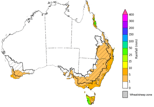
Over the 8-days to 31 August 2023, fronts and troughs are expected to bring isolated showers to south-eastern parts of the country. A high-pressure system is expected to bring mainly dry conditions to the remainder of the country.
Across cropping regions, minimal rainfall totals of up to 5 millimetres are expected across much of New South Wales and Queensland, in central South Australia and southern Western Australia. Little to no rainfall is expected remaining areas.
These falls are likely to be of little benefit to crops and pastures as they are unlikely to be sufficient to offset evaporative losses. Following a dry August so far in Queensland and northern New South Wales and given the current well below average levels of soil moisture, crops and pastures is these areas will be disposed to heat and moisture stress, negatively affecting production potential.
Total forecast rainfall for the period 23 August 2023 to 31 August 2023
Note: This rainfall forecast is produced from computer models. As the model outputs are not altered by weather forecasters, it is important to check local forecasts and warnings issued by the Bureau of Meteorology.
Water
Water storages, water markets and water allocations - current week
The Tableau dashboard may not meet accessibility requirements. For information about the contents of these dashboards contact ABARES.
Commodities
Information on weekly price changes in agricultural commodities is now available at the Weekly commodity price update.


