Key issues
- In the week ending 21 August 2024, a series of low-pressure troughs and cold fronts brought rainfall totals of up to 150 millimetres to Western Australia and up to 100 millimetres in eastern and southern regions.
- Across cropping regions, rainfall totals ranging from 5 to 25 millimetres were recorded across Victoria and South Australia, and parts of New South Wales and Queensland. Meanwhile, Western Australian cropping regions recorded falls of between 5 and 50 millimetres. This rainfall will not only support the yield prospects of winter crops in southern regions, but also assist in the build-up of soil moisture reserves particularly in southern Western Australia.
- Over coming days, low-pressure systems are expected to bring rainfall to southern parts of the country. High-pressure systems are expected to keep the central and northern parts of the country largely dry.
- Across cropping regions, rainfall totals of between 10 and 50 millimetres are forecast across Western Australia, with higher rainfall totals in the far south-western regions. Meanwhile, Victoria and New South Wales are expected to receive between 5 and 25 millimetres of rainfall, with South Australia forecast for between 5 and 10 millimetres.
- The national rainfall outlook for Spring 2024 indicated an increased probability of above median rainfall across eastern and south-western areas of the country.
- Across eastern cropping regions, the probability of exceeding median rainfall is between 45% and 70%.
- There is at least a 75% chance of receiving between 50 and 200 millimetres of rainfall across Queensland and New South Wales, and between 25 and 100 millimetres in the remaining states. If realised, these expected rainfall totals will likely be sufficient to support the flowering and grain filling stages of winter crop development, boost soil moisture profiles, assist in maintaining current winter crop yield expectations in most regions and provide a favourable start to the summer cropping season.
- Water storage levels in the Murray-Darling Basin (MDB) increased between 15 August 2024 and 22 August 2024 by 121 gigalitres (GL). Current volume of water held in storage is 18 315 GL, equivalent to 82% of total storage capacity. This is 10% or 2,582GL less than at the same time last year. Water storage data is sourced from the BOM.
- Allocation prices in the Victorian Murray below the Barmah Choke increased from $146 on 15 August 2024 to $148 on 22 August 2024. Prices are lower in the Murrumbidgee due to the binding of the Murrumbidgee export limit.
Climate
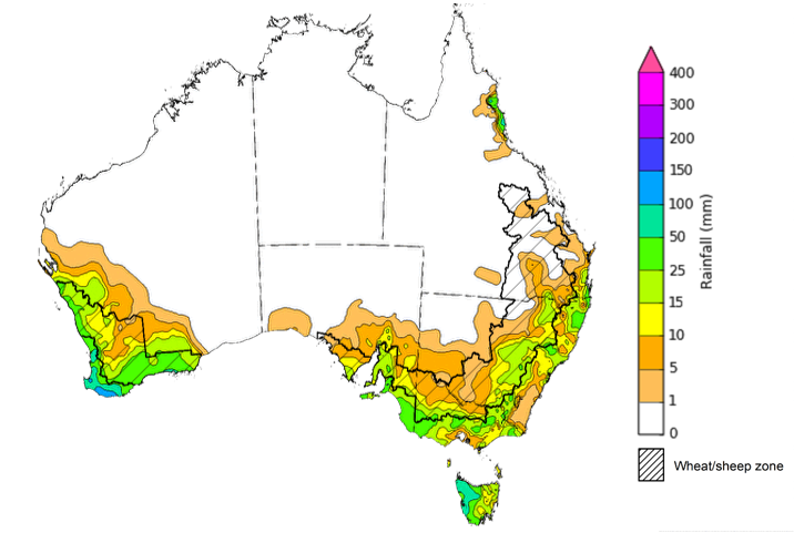
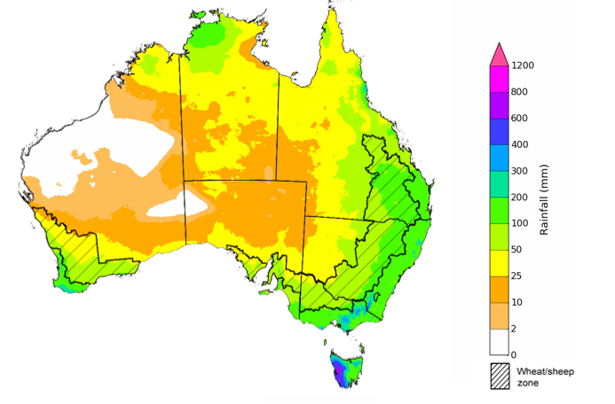
For the week ending 21 August 2024, cold fronts and a series of low-pressure troughs brought rainfall to the southeast, southwest and northeast of Australia. Up to 50 millimetres of rainfall was recorded in southern South Australia and Victoria, and eastern parts of New South Wales and Queensland. High-pressure systems kept central and northern regions dry. A cold front bought a maximum of 100 millimetres of rainfall to Tasmania and up to 150 millimetres to the southwest of Western Australia.
Across cropping regions, rainfall totals ranging from 5 to 25 millimetres were recorded across eastern and central New South Wales and scattered areas of southern Queensland. Falls of between 5 and 25 millimetres were recorded across South Australia and Victoria, while Western Australian cropping regions recorded rainfall totals of between 5 and 50 millimetres of rainfall. This rainfall will not only support the yield prospects of winter crops in southern regions, but also assist in the build-up of soil moisture reserves particularly in southern Western Australia. Little to no rainfall across parts of northern and western New South Wales and much of Queensland cropping regions is expected to contribute to a decline in soil moisture, as crops utilised average to above average levels of stored soil moisture to maintain current yield potentials.
Rainfall for the week ending 21 August 2024
Issued: 21/08/2024
Note: The rainfall analyses and associated maps utilise data contained in the Bureau of Meteorology climate database, the Australian Data Archive for Meteorology (ADAM). The analyses are initially produced automatically from real-time data with limited quality control. They are intended to provide a general overview of rainfall across Australia as quickly as possible after the observations are received. For further information go to http://www.bom.gov.au/climate/rainfall/
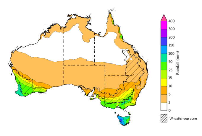
Over the 8 days to 29 August 2024, low-pressure systems are expected to bring rainfall to southern parts of the country. High-pressure systems are expected to keep the central and northern parts of the country largely dry.
Across cropping regions, rainfall totals of between 10 and 50 millimetres are forecast across Western Australia, with higher rainfall totals in the far south-western regions. Meanwhile, Victoria and southern and central New South Wales are expected to receive between 5 and 25 millimetres of rainfall, with much of South Australia forecast to receive between 5 and 10 millimetres. Little to no rainfall is forecast for northern New South Wales and Queensland cropping regions, with a maximum of 5 millimetres of rainfall. If realised, rainfall in these cropping areas is expected to provide a boost to plant growth and soil moisture levels in southern regions, with crops in northern New South Wales and Queensland to remain reliant on stored soil moisture to support growth. However, South Australia cropping regions require timely rainfall over the coming weeks.
Total forecast rainfall for the period 22 August to 29 August 2024
Issued 22/08/2024
Note: This rainfall forecast is produced from computer models. As the model outputs are not altered by weather forecasters, it is important to check local forecasts and warnings issued by the Bureau of Meteorology.
The most recent rainfall outlook for September 2024 provided by the Bureau of Meteorology indicates an increased likelihood of above median rainfall across the northeast, southeast and southwest of mainland Australia, as well as much of Tasmania. In contrast, there is an increased likelihood of below median rainfall across parts of northern Queensland, northern and central areas of Western Australia and western South Australia.
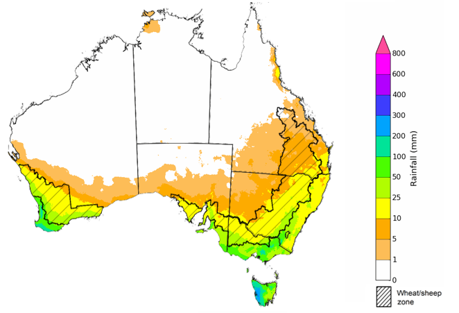
According to Bureau of Meteorology’s climate model, for September 2024 there is a 75% probability of rainfall totals between 10 and 100 millimetres across eastern New South Wales, Victoria, and southern areas of South Australia and Western Australia. Southern Queensland is expected to receive up to 25 millimetres of rainfall. Alpine areas in New South Wales, Victoria, and the far west of Western Australia will likely receive rainfall of up to 200 millimetres. Tasmania is expected to receive up to 300 millimetres of rainfall. The northern areas of the country are expected to remain largely dry, typical of this time of year, with exceptions in parts of the tropical northeast Queensland where up to 25 millimetres of rainfall are expected.
Across cropping regions, there is a 75% chance of receiving between 10 and 50 millimetres of rainfall in New South Wales, Victoria, South Australia and Western Australia. Isolated areas in these states can receive up to 100 millimetres of rainfall. In Queensland, rainfall totals of between 5 and 25 millimetres are expected across southern cropping regions, while little to no rainfall is expected for northern cropping regions. If realised, these rainfall totals are likely to be sufficient to support growth of crops through remaining of winter. In Queensland cropping regions, this expected lack of rainfall in the central to northern areas is unlikely to negatively impact winter crop development, due to above average levels of stored soil moisture maintain current yield potentials.
Rainfall totals that have a 75% chance of occurring in September 2024
Issued: 22/08/2024
The El Niño Southern Oscillation (ENSO) and Indian Ocean Dipole (IOD) climate drivers are currently neutral and having minimal influence on Australian rainfall.
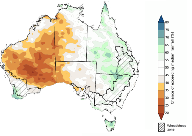
The rainfall outlook for September through November 2024 indicates that above median rainfall is more likely across eastern and southern areas of the country. In contrast, much of Western Australia, and western areas in the Northern Territory and South Australia are expected to receive below median rainfall, with the probability below 40% of exceeding median rain in these areas. Remaining areas have equal chance of receiving above or below median rainfall.
Across cropping regions, the probability of receiving median rainfall is between 45% and 70% in Queensland, New South Wales and Western Australia. There is an equal chance of either above or below median rainfall in eastern South Australia and Victorian cropping regions. If realised, this rainfall would support ABARES forecasts of above average winter crop yields in New South Wales, Western Australia and Queensland, and help support current yield expectations in Victoria and South Australia.
Chance of exceeding the median rainfall September to November 2024
Note: The world precipitation percentiles indicate a ranking of precipitation for March, with the driest (0th percentile) being 0 on the scale and the wettest (100th percentile) being 1 on the scale. Percentiles are based on precipitation estimates from the NOAA Climate Prediction Center’s Climate Anomaly Monitoring System Outgoing Precipitation Index dataset. Precipitation estimates for April 2024 are compared with rainfall recorded for that period during the 1981 to 2010 base period. Source: International Research Institute for Climate and Society
The outlook for September through to November suggests a 75% chance of rainfall totals between 25 and 200 millimetres occurring in the eastern, southern and northern part of the country, with heavier falls of up to 600 millimetres forecast for alpine regions of Victoria and New South Wales. Western Tasmania is expected to receive falls in excess of 600 millimetres.
In cropping regions, there is at least a 75% chance of receiving between 50 and 200 millimetres of rainfall across much of Queensland and New South Wales, and between 25 and 100 millimetres in Victoria, South Australia and Western Australia.
These expected rainfall totals are likely to be sufficient to support the flowering and grain filling stages of winter crop development, boost soil moisture profile, assist in maintaining current winter crop yield expectations in most regions and provide a favourable start to the summer cropping season.
Livestock producers, especially those in the south and east of the country, are expected to experience close to average pasture production on the back of the improving rainfall outlook over the spring season.
Rainfall totals that have a 75% chance of occurring September to November 2024
The northern rainfall onset outlook provides an indication of whether the first significant rains after the dry season are likely to be earlier or later than normal. The onset occurs when the total rainfall after 1 September reaches 50 millimetres, which is considered approximately the amount of rainfall required to stimulate plant growth. The northern rainfall onset for the 2024–25 season is likely to be later than usual for most of the western and central parts of northern Australia, but earlier for parts of the east. Much of Western Australia, the Northern Territory, and western Queensland have a 60–70% chance of a later than usual northern rainfall onset. The Pilbara coast in Western Australia, and parts of eastern Queensland have a 60–70% chance of an earlier than usual northern rainfall onset. Elsewhere, the northern rainfall onset is likely to be closer to the normal onset date.
Chance of early Northern Rainfall Onset
![Map showing the chance of exceeding median rainfall during the next three months in Australia. Image provided by the Bureau of Meteorology. Please refer to accompanying text for a more detailed description.]](/sites/default/files/images/20240815.nro_.forecast.mr_.png)
Water
Water storages, water markets and water allocations - current week
The Tableau dashboard may not meet accessibility requirements. For information about the contents of these dashboards contact ABARES.
Commodities
Information on weekly price changes in agricultural commodities is now available at the Weekly commodity price update.
