Key issues
- For the week ending 19 October 2022, low-pressure systems to the south of Australia and an associated cold front brought significant rainfall to much of south-eastern Australia. Weekly rainfall totals exceeding 50 millimetres were observed across parts of southern New South Wales, central Queensland, central Victoria, southern and central South Australia and northern Tasmania. Rainfall events across New South Wales and Victorian cropping regions has led to flooding across several river catchments (see Flooding in eastern Australia section). The flooding in low-lying areas is expected to cause significant damage and crop losses for some growers. Moderate to heavy rainfall across the Central Queensland region likely interrupted the harvesting of winter crops and the sowing of long-season summer crops.
- Intense rainfall during September and October has led to flash and riverine flooding across large areas of eastern Australia. This has likely resulted in winter grain and oilseed, horticultural, livestock and dairy production losses for producers in the worst affected areas. The recent heavy rainfall may also lead to yield loses in some recently sown crops due to lengthy inundation. It could limit the ability to undertake the harvesting of winter crops and the planting of summer crops if it remains too wet to get into paddocks.
- Below average rainfall globally during September is likely to result in lower-than-expected wheat production potential in Argentina, the United States, and parts of the Russian Federation. Further, the conflict in Ukraine continues to generate uncertainty around wheat, corn and sunflower production for 2022 and 2023. Below average rainfall and above average temperatures in recent months have also negatively affected corn production across parts of Argentina, Brazil, the European Union and the United States. Global production conditions have deteriorated compared to those used to formulate ABARES forecasts of global grain supplies and world prices in its September 2022 edition of the Agricultural Commodities Report. As a result, global grain and oilseed production is likely to be lower than that forecast earlier in September.
- Over the 8-days to 27 October 2022, a persistent low-pressure system and associated trough is forecast to bring significant rainfall across eastern Australia. Meanwhile, little to no rainfall is expected for remaining parts of the country. Heavy rainfall across south-eastern Australia is likely to exacerbate flooding of low-lying areas. Prolonged inundation will increase the risk of abandonment of winter crops as well as quality downgrades. Yield potentials for crops not impacted by flooding in south-eastern Australia remain very favourable.
- Water storage in the Murray–Darling Basin (MDB) increased by 84 gigalitres (GL) between 12 October 2022 and 19 October 2022. The current volume of water held in storage is 23,994 GL, which represents 95% of total capacity. This is 8% or 1,811 GL more than at the same time last year.
- Allocation prices in the Victorian Murray below the Barmah Choke decreased from $38 per ML on 7 October to $35 per ML on 14 October 2022. Prices are lower in the Murrumbidgee and regions above the Barmah choke due to the binding of the Murrumbidgee export limit and the Barmah choke trade constraint.
Climate
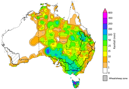
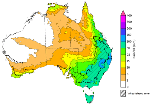
For the week ending 19 October 2022, low-pressure systems to the south of Australia and an associated cold front brought significant rainfall to much of south-eastern Australia. Weekly rainfall totals exceeding 50 millimetres were observed across parts of southern New South Wales, central Queensland, central Victoria, southern and central South Australia and northern Tasmania. High-pressure systems over southern and western parts of the country resulted in clear, dry conditions in most areas.
In Australian cropping regions, rainfall totals of between 10 and 50 millimetres were recorded across much of New South Wales, south-western Queensland, western Victoria, as well as much of South Australia. Falls in excess of 50 millimetres were recorded across southern New South Wales, northern Queensland and much of Victoria. Little to no rainfall was recorded in remaining cropping regions of south-east Queensland and Western Australia for the week ending 19 October 2022.
Rainfall events across New South Wales and Victorian cropping regions has led to flooding across several river catchments (see Flooding in eastern Australia section). The flooding in low-lying areas is expected to cause significant damage and crop losses for some growers. However, the full extent of damage is yet unknown. Further rainfall over the coming days is likely to exacerbate current conditions. The wet conditions have also increased disease pressure, especially for pulse crops across southern New South Wales and western Victoria, which is likely to negatively impact yields and crop quality. For winter crops not impacted by prolonged waterlogging, yield potentials remain very favourable
Moderate to heavy rainfall across the Central Queensland region likely interrupted the harvesting of winter crops and the sowing of long-season summer crops. Meanwhile, relatively light rainfall for parts of south-east Queensland will have supported crop maturation and allowed soil profiles to drain. In South Australia and Western Australia, yield prospects remain very favourable given the seasonal conditions to-date. Given the current wet conditions and an expectation for above average rainfall for the coming months, we are likely to see a drawn-out harvest to the 2022 winter cropping season.
Rainfall for the week ending 19 October 2022
Note: The rainfall analyses and associated maps utilise data contained in the Bureau of Meteorology climate database, the Australian Data Archive for Meteorology (ADAM). The analyses are initially produced automatically from real-time data with limited quality control. They are intended to provide a general overview of rainfall across Australia as quickly as possible after the observations are received. For further information go to http://www.bom.gov.au/climate/rainfall/
Intense rainfall during September and October has led to flash and widespread riverine flooding across large areas of southern Queensland, New South Wales, Victoria and Tasmania. This has likely resulted in winter grain and oilseed, horticultural, livestock and dairy production losses for producers in the worst affected areas.
Flooding is forecast to continue across many catchments over New South Wales and Victoria, and emerge across Queensland in the coming days, as flood peaks move downstream and with heavy rainfall forecast for much of Australia’s eastern seaboard during the next 8 days.
It is too early to say what the full impact this flooding across extensive areas of New South Wales, Victoria and Tasmania will be on agricultural producers and communities. As the event is still ongoing many farmers will still be surveying the damage, with limited ability to undertake detailed assessments at this stage.
There will be significant localised impacts. While the damage will reduce the value of production across many states, national production quantities and aggregate exports will be supported by close to record production expected in South Australia and Western Australia.
Road and rail networks have also seen temporary cuts in some instances, and we expect there will be extensive damage to farm buildings, fencing and roads. Supply chain impacts on processors and transport logistics will be important in determining the final impacts are on the sector.
The heavy rainfalls recorded across south-eastern Australia in early October follows well above average rainfall throughout September 2022. This above average rainfall has left soils in most catchments saturated and with many dams and water storages at capacity, waterways are very sensitive to rainfall, and flooding is expected to continue for several months.
Flooding, as considered here, is generally a localised event and tends to follow river valleys, spreading across the flood plain and lower lying areas to varying extents. As a proportion of total land, the actual area of land affected is usually relatively small. Flood impacts can be caused by flash flooding or when floodwaters inundate an area for a long period of time.
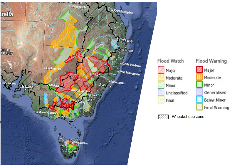
At the height of the current flood event (15 October 2022) major flood warnings were in place for 8, 11 and 3 river catchments in New South Wales, Victoria, and Tasmania respectively. While moderate flood warnings were in plain in an additional 10, 11 and 5 river catchments in New South Wales, Victoria, and Tasmania respectively, and river catchments in Queensland
Flood watch and warning areas on 15 October 2022
As at 20 October 2022 flood watches remain current for South Australia, Queensland, and New South Wales as forecast rainfall may lead to flash and riverine flooding and renewed river level rises in these areas.
Flooding warnings are current for the following catchments in New South Wales: Gwydir, Namoi, Macquarie, Bogan, Lachlan, Murrumbidgee, Murray, Edward, Culgoa, Bokhara, Warrego, Paroo, Barwon, Darling Rivers, Macintyre (Qld) and Mirrool Creek.
Flooding warnings are current for the following catchments in Queensland: Condamine Rivers, Macintyre River, Weir River, Moonie River, Balonne River, Barcoo River.
Summary of potential impacts by sector
Cropping
Cropping in areas most affected by flooding is not yet ready to harvest. For inundated areas, loss of crops is expected. In other areas, the effects of the heavy rainfall will be quality downgrades and some losses to winter grain crops, largely wheat, canola and barley.
Waterlogging will also make it difficult to access paddocks in the coming weeks and months, presenting and ongoing challenge leading up to harvest.
Flooding and high rainfall is also likely to have damaged some early sown summer crops due to lengthy inundation and could limit the ability to complete remaining summer crops planting if it remains too wet to get into paddocks.
Livestock and Livestock products including
Losses of livestock reported to date have been small in relation to the national herd and flock. The main impact for livestock appears to have been associated with disruptions to transport to markets and the closure of processing establishments.
Road closures in some regions have prevented the collection of milk. Infrastructure, crops and feed stores have been damaged on some farms. The floods could also increase the incidence of mastitis and loss of milk production due to stress.
Horticulture
Reported horticultural losses have been small in relation to the national production.
The impact for horticulture at this stage appears to have been disruptions to transport to markets and the closure of processing establishments, particularly in Victoria.
The impact of floods on prices of fruit and vegetables is likely to put upward pressures on prices in the short term.
Future price increases for fruit and vegetables will depend on the extent of further rainfall and flooding. This may also affect producers’ ability to plant their next fruit and vegetable crops.
Crop production is affected by long-term trends in average rainfall and temperature, interannual climate variability, shocks during specific growth stages, and extreme weather events (IPCC 2012). Some crops are more tolerant than others to certain types of stresses, and at each growth stage, different types of stresses affect each crop species in different ways.
The precipitation anomalies and outlooks presented here give an indication of the current and future state of production conditions for the major grain and oilseed producing countries which are responsible for over 80% of global production. This is an important input to assessing the global grain supply outlook.
September precipitation percentiles and current production conditions
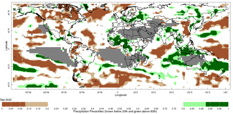
As of the end of September 2022, rainfall was below average for a number of the world’s major grain-producing and oilseed-producing regions.
In the northern hemisphere, precipitation was below average across parts of central and southern United States, much of Canada, eastern China and parts of Kazakhstan. Precipitation was above average for central and eastern Europe, western parts of the Russian Federation and south-western China. Precipitation was close to average across the remainder of the major grain-producing and oilseed-producing regions in the northern hemisphere.
In the southern hemisphere, September precipitation was below average for parts of central Argentina. Precipitation was above average for parts of eastern Australia and the southwest of Brazil. Precipitation was close to average across the remainder of major grain-producing and oilseed-producing regions in the southern hemisphere.
Global precipitation percentiles, September 2022
Source: International Research Institute for Climate and Society
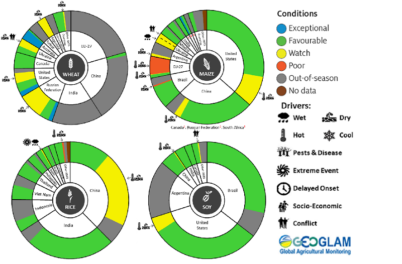
As at 28 September 2022 global production conditions were generally favourable for soybeans and rice, but quite variable for the production of wheat and corn.
In the northern hemisphere production conditions for wheat have been mixed. Spring wheat harvesting is drawing to a close in Canada, China, the Russian Federation and the United States under favourable to exceptional conditions. However, dry conditions threaten the establishment of winter wheat in the Russian Federation and the United States as sowing continues. In the Ukraine, the ongoing war and dry conditions are impacting winter wheat sowing. In the southern hemisphere, production conditions are exceptionally good in parts of Australia, but excessively wet conditions are impacting wheat in some eastern regions. In Argentina, dry conditions have persisted across central and northern growing regions, with recent rainfall improving conditions in southern regions.
In Argentina, sowing of early-planted corn continues under dry conditions. The harvesting of main corn crop is drawing to a close under favourable conditions in the central-west and southern regions of Brazil, with poor conditions in the south-east. Planting of spring-sown corn is underway in the south under favourable conditions. In Mexico, sowing for the spring-summer season is wrapping up under favourable conditions. In the European Union, drought conditions throughout summer have resulted in a poor yield outlook for corn across the region. Hot, dry conditions have negatively impacted yield prospects in parts of China and the United States, while conditions in other areas remain favourable. Across Indian growing regions, sowing of the Kharif crop is complete and conditions appear favourable. In Ukraine, heavy rainfall and below average temperature have delayed crop maturation in some parts, while ongoing war in southern and eastern regions is negatively impacting production.
Extreme heat and dry conditions throughout summer in China’s Yangtze River basin have negatively impacted yield potentials for single-season and late-season rice. Growing conditions remain favourable in other regions. In the Philippines and Thailand, plant growth of wet-season rice is continuing under generally favourable conditions. In Vietnam, wet-season rice is continuing under favourable conditions in the north, while harvesting continues in the south for wet-season rice. Sowing of dry-season rice enters the late stages in Indonesia, and harvesting of earlier sown crops continue under favourable conditions. In India, conditions are favourable across growing regions as harvesting approaches in the northern states. Overall, planted area is slightly down compared to last year in the eastern states. A typhoon has brought heavy rainfall and flooding to parts of southern Japan, negatively impacting rice crops. However, conditions remain favourable in other regions.
In the United States, growing conditions remain generally favourable for soybeans as harvesting begins. However, hot, dry conditions in some regions have negatively impacted crops. Conditions remain largely favourable across Canada, China and India, with harvesting continuing in Canada and China, and crops in India maturing. In Ukraine, climatic conditions remain supportive of harvesting in western, central and northern regions, while the war continues to bring uncertainties in eastern and southern areas. Sowing in underway in Brazil with favourable conditions in the south and parts of the central-west.
Crop conditions, AMIS countries, 28 September 2022
Source: AMIS
The global climate outlook for November 2022 to January 2023 indicates that variable rainfall conditions are expected for the world's major grain-producing and oilseed-producing regions. Outlooks and potential production impacts for the major grain and oilseed producing countries are presented in the table.
Rainfall outlook and potential impact on the future state of production conditions between November 2022 to January 2023
| Region | November to January rainfall outlook | Potential impact on production |
|---|---|---|
| Argentina | Below average rainfall is expected across most of Argentina between November to January 2022. | Below average rainfall is likely to adversely affect the silking, flowering and grain filling of corn, as well as the flowering of cotton, ground nuts, soybeans and sunflowers. The dry conditions mays also negatively impact the planting and vegetative growth of millet, rice and sorghum. |
| Black Sea Region | Below average rainfall is forecast for southern Kazakhstan, eastern Ukraine, southern parts of the Russian Federation and Turkey. For remaining areas there is no strong tendency towards either above or below average rainfall between November to January 2022. | Winter wheat and canola will remain dormant throughout November to January across the Black Sea Region. Below average rainfall in many parts may provide insufficient snowpack to protect crops from winterkill. |
| Brazil | Above average rainfall is more likely in northern and central Brazil, while below average rainfall is more likely across the south of Brazil. | Below average rainfall in parts of southern Brazil will provide favourable conditions for harvesting of wheat in November. However, below average rainfall is likely to adversely affect flowering of corn, cotton, groundnuts and soybeans, as well as the grain filling on corn in January. Above average rainfall in northern and central Brazil will benefit the growth, flowering and filling of soybeans. |
| Canada | Above average rainfall is expected across parts of Alberta, Ontario and Saskatchewan, but there is no strong tendency towards below or above average rainfall across remaining parts of Canada between November to January 2022. | Average to above average rainfall in parts of Canada may delay harvesting and cause grain quality concerns for corn, soybean and sunflower in November. Average to above average rainfall is also likely to provide sufficient snowpack to prevent winterkill of winter wheat and canola through December and January. |
| China | Above average rainfall is likely in parts of central China and below average across northern, western and south-eastern China in November to January 2022. | Below average rainfall in northern, western and south-eastern China is likely to benefit the harvesting of cotton, corn, sorghum, soybean, sunflower and groundnuts. However, dry conditions across northern and western China may limit snowpack, increasing the risk of winterkill for winter wheat and canola. |
| Europe | Below average rainfall more likely for parts of central Europe, while above average rainfall is expected in parts of southern Europe between November to January 2022. | Below average rainfall may limit snowpack in parts of central Europe, increasing the risk of winterkill for winter wheat and canola. Meanwhile, close to average rainfall through November to January should provide sufficient snowpack for dormant crops in northern Europe. |
| South Asia (India) | Close to average rainfall is forecast for much of India, with above average rainfall in southern India and below average rainfall expected in parts of northern and south-eastern India. | Close to average rainfall across much of India will support the harvesting of corn, cotton, groundnuts, millet, rice, sorghum and sunflower. However, below average rainfall in parts of northern India may negatively impact the vegetative growth and heading of winter wheat and canola. |
| Southeast Asia (SEA) | A strong likelihood of above average rainfall is forecast across SEA between November to January 2022. | Above average rainfall in SEA is likely to benefit the growth and development of dry-season rice throughout November to January. |
| The United States of America | Above average rainfall is more likely for parts of the north-western US and below average rainfall is more likely across much of southern US. | Below average rainfall across southern US is likely to support harvesting of corn, sorghum and soybeans in November. Average to above average rainfall conditions expected across the northern US is likely to provide sufficient snow cover through December and January to protect winter wheat and canola through dormancy. |
Over the 8-days to 27 October 2022, a persistent low-pressure system and associated trough is forecast to bring significant rainfall across eastern Australia. Meanwhile, little to no rainfall is expected for remaining parts of the country.
In Australian cropping regions, rainfall totals of between 10 and 50 millimetres are expected across parts of southern New South Wales and western Queensland, western Victoria, much of South Australia, and southern parts of Western Australia. Rainfall in excess of 50 millimetres is forecast for much of New South Wales, Queensland, and eastern Victorian cropping regions. Little to no rainfall is forecast for remaining cropping regions in the west of South Australia and Western Australia during the next 8-days.
Heavy rainfall across south-eastern Australia is likely to exacerbate flooding of low-lying areas. Prolonged inundation will increase the risk of abandonment of winter crops as well as quality downgrades. Yield potentials for crops not impacted by flooding in south-eastern Australia remain very favourable. However, soil moisture levels are well above average, and the forecast rainfall is unlikely to benefit yields further. The wet conditions will further increase disease pressure for winter crops while limiting field access for disease management. The interruptions to harvesting of winter crops and the planting of long-period summer crops in Central Queensland is expected to be delayed further. The wet conditions will also further delay the maturation of winter crops and the start of harvesting activities for remaining regions of eastern Australia.
The outlook for winter crops across South Australia and Western Australia remains very promising. Light to moderate rainfall across parts of South Australia may increase disease pressure slightly, but ideal conditions for the season to-date have established strong yield potentials. Likewise, another large winter crop is expected in Western Australia as conditions remain favourable for crop maturation.
Total forecast rainfall (mm) for the period 20 October to 27 October 2022
Note: This rainfall forecast is produced from computer models. As the model outputs are not altered by weather forecasters, it is important to check local forecasts and warnings issued by the Bureau of Meteorology.
Water
Water storages, water markets and water allocations - current week
The Tableau dashboard may not meet accessibility requirements. For information about the contents of these dashboards contact ABARES.
Commodities
Information on weekly price changes in agricultural commodities is now available at the Weekly commodity price update.

