Key issues
- In the week ending 31 July 2024, cold fronts and a series of troughs brought rainfall to south-west, southern and eastern Australia, while a high-pressure system kept remaining areas largely dry.
- Across cropping regions, rainfall totals of between 5 and 50 millimetres were recorded in Western Australia and northern half of New South Wales. Falls of between 5 and 25 millimetres were recorded in southern Queensland and parts of southern New South Wales, Victoria and South Australia. Little to no rainfall was recorded elsewhere.
- Over coming days, a series of cold fronts and low-pressure systems are expected to bring rainfall across central and southern parts of the country.
- Across cropping regions, rainfall totals of between 5 and 25 millimetres are forecast for Western Australia and northern New South Wales, while much of Queensland is expected to see between 5 and 15 millimetres. Much of southern New South Wales, Victoria and South Australia are expected to receive little to no rainfall forecast for the next 8-days. Relatively dry conditions in southern New South Wales, Victoria and South Australia will likely see a drawdown in sub-soil moisture levels.
- Nationally, July rainfall was extremely high in the central and northern parts of Australia. Below average rainfall was recorded in parts of northern Western Australia, in Victoria, western Tasmania and in isolated areas in Queensland.
- The national rainfall outlook for August to October is a high probability of above median rainfall across interior, eastern and southwestern areas of the country.
- Across most cropping regions, the probability of exceeding median rainfall is between 45% and 80%. If realised, these expected rainfall totals will likely be sufficient in maintaining above average winter crops yields and provide a favourable start to the summer cropping season.
- Northern rainfall onset of at least 50 millimetres accumulation from September 1 is forecast to be later than usual in the west of the country and earlier than usual in the east.
- Water storage levels in the Murray-Darling Basin (MDB) increased between 25 July 2024 and 01 August 2024 by 266 gigalitres (GL). Current volume of water held in storage is 17 876 GL, equivalent to 80% of total storage capacity. This is 14% or 2,833 GL less than at the same time last year. Water storage data is sourced from the BOM.
- Allocation prices in the Victorian Murray below the Barmah Choke increased from $116 on 25 July 2024 to $134 on 01 August 2024. Prices are lower in the Murrumbidgee due to the binding of the Murrumbidgee export limit.
Climate
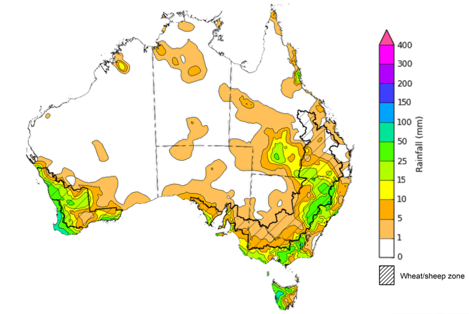
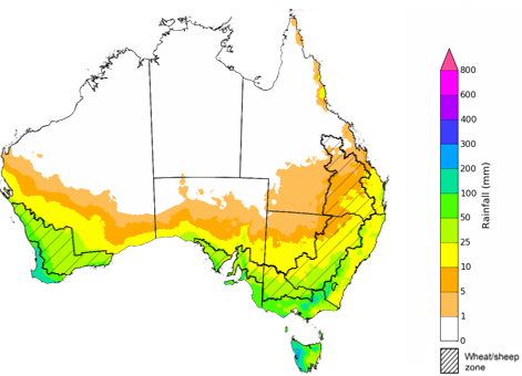
For the week ending 31 July 2024, cold fronts and a series of troughs brought rainfall to southwest, southern and eastern Australia, while a high-pressure system kept remaining areas largely dry. Up to 100 millimetres of rainfall was recorded in far south-western parts of Western Australia and western Tasmania. Parts of Victoria and New South Wales, and scattered areas of Queensland and South Australia recorded a maximum of 50 millimetres of rainfall.
Across cropping regions, rainfall totals of between 5 and 50 millimetres were recorded in Western Australia and northern half of New South Wales. Falls of between 5 and 25 millimetres were recorded in southern Queensland and parts of southern New South Wales, Victoria and South Australia. Remaining cropping areas recorded little to no rainfall.
Rainfall for the week ending 31 July 2024
Issued: 31/07/2024
Note: The rainfall analyses and associated maps utilise data contained in the Bureau of Meteorology climate database, the Australian Data Archive for Meteorology (ADAM). The analyses are initially produced automatically from real-time data with limited quality control. They are intended to provide a general overview of rainfall across Australia as quickly as possible after the observations are received. For further information go to http://www.bom.gov.au/climate/rainfall/
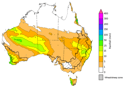
Over the 8 days to 8 August 2024, a series of cold fronts and low-pressure systems are expected to bring rainfall across central and southern parts of the country. Tasmania and isolated areas of Western Australia are forecast to receive a maximum of 50 millimetres of rainfall, and up to 25 millimetres is forecast for northern areas of New South Wales, southern Queensland and western South Australia. A maximum of 5 millimetres of rainfall is forecast across the remainder of southern and central Australia.
Across cropping regions, rainfall totals of between 5 and 25 millimetres are forecast for Western Australia and northern New South Wales, while much of Queensland is expected to see between 5and 15 millimetres. Meanwhile, much of southern New South Wales, Victoria and South Australia are expected to receive little to no rainfall forecast for the next 8-days. Relatively dry conditions in southern New South Wales, Victoria and South Australia will likely see a drawdown in sub-soil moisture levels.
Total forecast rainfall for the period 1 July to 8 August 2024
Issued 1/08/2024
Note: This rainfall forecast is produced from computer models. As the model outputs are not altered by weather forecasters, it is important to check local forecasts and warnings issued by the Bureau of Meteorology.
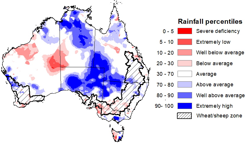
During July 2024, rainfall was well above average in large parts of central Australia, with central South Australia, western Queensland and north-western New South Wales experiencing extremely high rainfall. Despite being in the typical northern dry season, northern areas of Northern Territory saw extremely high rainfall in July. In contrast, parts of the interior and western areas of the Western Australia, isolated areas in Queensland, Victoria, South Australia and western Tasmania recorded below average rainfall.
In cropping regions, rainfall was mixed, with much of Western Australia, Queensland and New South Wales experiencing average rainfall. In contrast, areas of Victoria, eastern South Australia, and southern New South Wales saw below average rainfall. Following below average to average rainfall in the previous month, rainfall totals have likely been sufficient to support the establishment of winter crops, but has seen only marginal increase in stored soil moisture levels. Above average to extremely high rainfall was recorded in parts of northern Western Australia, northern New South Wales, and southern Queensland. Above average July rainfall in these areas has allowed for the build-up of soil moisture profile to support the crop development and is maintaining average to above average yield expectations.
Rainfall percentiles for July 2024
Source: Bureau of Meteorology
Frost occurs on clear nights during the late autumn to early spring period, when the air temperature drops to 2°C or lower and is most pronounced in the southern and eastern agricultural regions. The weather events that typically generate damaging frosts are from the passage of cold fronts, followed by cold southerly winds and a high-pressure ridge. The severity and extent of subsequent damage is variable across the landscape. Crop damage from frost may occur at any stage of development but is most damaging around flowering and grain filling in spring. During the early stages of plant growth, frost can damage emerging crop.
Severe frosts (minimum temperatures below -2°C) can cause freezing damage to a crop when there is rapid ice crystal formation form within the tissue. The ice crystals physically rupture cell walls and membranes within the cells. Damage can be seen once thawed as dark green water-soaked areas. Ten days after a frost event, bleached leaves, stems and reproductive tissue might be evident depending on the growth stage of the crop.
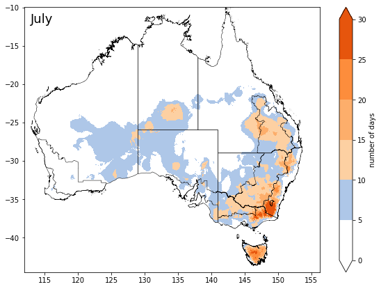
During July 2024, much of Victoria, New South Wales and Queensland, and parts of eastern and northern South Australia cropping regions experienced at least 5 frost events. Depending on the growth stage of crops and the severity and length of time crops were subjected to frost, this presents a localised risk to crop production in these areas.
Number of days with minimum temperature below 2°C in July 2024
Note: Based on standard 30-year climatology (1993-2022)
The most recent rainfall outlook for August 2024 provided by the Bureau of Meteorology indicates an increased likelihood of above median rainfall across much of Australia. There is an increased likelihood of below median rainfall across parts of northern Australia and southern parts of Tasmania.
According to Bureau of Meteorology’s climate model, for August 2024 there is a 75% probability of rainfall totals between 10 and 100 millimetres across much of New South Wales, Victoria, Tasmania, southern South Australia and Western Australia. Southern Queensland is expected to receive up to 25 millimetres of rainfall. Alpine areas in New South Wales, Victoria, and the far west of Western Australia will likely receive rainfall of up to 200 millimetres. Tasmania is expected to receive up to 300 millimetres of rainfall in western areas. The northern areas of the country are expected to remain largely dry, typical of this time of year, with exceptions in parts of the tropical northeast Queensland where up to 25 millimetres of rainfall are expected.
Across cropping regions, there is a 75% chance of receiving between 10 and 50 millimetres of rainfall in New South Wales, Victoria, South Australia and Western Australia. Isolated areas in these states may receive up to 100 millimetres of rainfall. In Queensland, rainfall totals of between 5 and 25 millimetres are expected across southern cropping regions, while little to no rainfall is expected for northern cropping regions. If realised, these rainfall totals are likely to be sufficient to support growth of crops through remaining of winter. In Queensland cropping regions, this expected lack of rainfall in northern areas may have a negative effect on the winter crop development.
Rainfall totals that have a 75% chance of occurring in August 2024
Issued: 01/08/2024
The El Niño Southern Oscillation (ENSO) and Indian Ocean Dipole (IOD) climate drivers are currently neutral and having minimal influence on Australian rainfall.
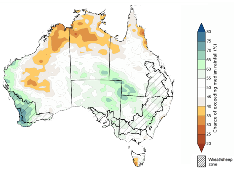
The rainfall outlook for August through October 2024 indicates that above median rainfall is more likely across the interior, and eastern and south-western areas of the country. In contrast, much of the north is expected to receive below median rainfall, with parts of Western Australia, the Northern Territory, and parts of tropical Queensland having a probability of median rainfall below 40%. Remaining areas have equal chance of receiving above or below median rainfall.
Across cropping regions, the probability of receiving median rainfall is between 45% and 80%, where higher probability of exceeding median rainfall is expected in Western Australia and in central parts of New South Wales. If realised, this rainfall would support ABARES forecasts of above average winter crop yields.
Chance of exceeding the median rainfall August to October 2024
Issued: 01/08/2024
The outlook for August through to October suggests a 75% chance of rainfall totals between 25 and 200 millimetres occurring in the southern part of the country, with heavier falls of up to 600 millimetres forecast for isolated areas of far southwest Western Australia, and alpine regions of Victoria and New South Wales. Western Tasmania is expected to receive falls in excess of 600 millimetres in isolated areas. In Queensland, falls of between 25 and 100 millimetres are expected in the southeast and parts of the northeast, with coastal areas likely to receive up to 200 millimetres of rainfall. Much of the remainder of the country is expected to receive little to no rainfall, typical of this time of the year.
In cropping regions, there is at least a 75% chance of receiving between 50 and 200 millimetres of rainfall across much of New South Wales, Victoria, South Australia and Western Australia. In Queensland, falls of between 25 and 100 millimetres are expected, with drier conditions forecast for far northern cropping regions.
These expected rainfall totals are likely to be sufficient to support the growth and development of winter crops, boost soil moisture profile and assist in maintaining above average crops yields in most winter regions and provide a favourable start to the summer cropping season.
Livestock producers, especially those in the south, are expected to experience close to average pasture production on the back of the improving rainfall outlook over the August to October period.
Rainfall totals that have a 75% chance of occurring August to October 2024

Issued: 01/08/2024
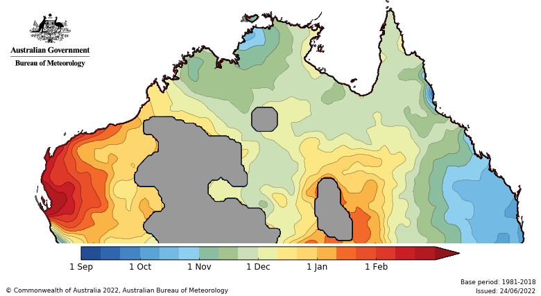
The timing of Northern Australia rainfall onset is important indicator for seasonal pasture growth and potential livestock production. The rainfall onset gives an indication of the accumulation of at least 50 millimetres of rainfall after 1 September to stimulate plant growth after the northern dry season.
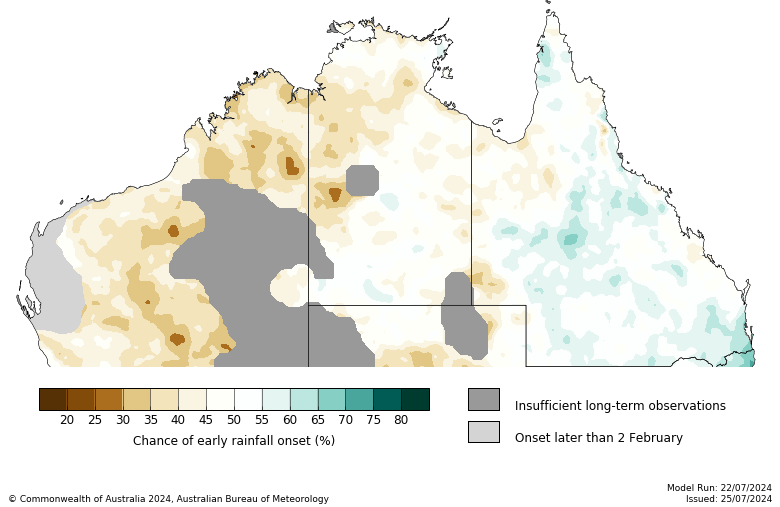
The outlook for the 2024–25 season indicates later than usual rainfall onset likely in the west and earlier in the east. Most of Western Australia, western and northern areas of Northern Territory, and some small pockets of western Queensland have a 60 to 70% chance of a later than usual northern rainfall onset. Parts of Queensland have a 60 to 70% chance of an earlier than usual northern rainfall onset. Elsewhere, the northern rainfall onset is likely to be closer to the average.
Chance of early northern rainfall onset
Historical northern rainfall onset date
Water
Water storages, water markets and water allocations - current week
The Tableau dashboard may not meet accessibility requirements. For information about the contents of these dashboards contact ABARES.
Commodities
Information on weekly price changes in agricultural commodities is now available at the Weekly commodity price update.
