
Key issues
- In the week ending 12 March 2025, Tropical Cyclone (TC) Alfred and low-pressure systems brought rainfall to eastern and northern Australia
- Rainfall totals were low in southern cropping regions, with between 0-5 millimetres in Western Australia and South Australia, and up to 15 millimetres in Victoria.
- In summer cropping regions, rainfall totals were generally high, with much of Queensland seeing between 5-150 millimetres of rainfall, and north-eastern New South Wales seeing 5 - 100 millimetres.
- Over the coming eight days, rainfall totals are expected to be high in northern and western regions.
- Rainfall totals of between 10-50 millimetres are forecast for cropping regions in northern Queensland and Western Australia. If realised, these falls are likely to boost soil moisture for late planted summer crops and ahead of the planting of winter crops, however, this may bring some delays to the harvesting of earlier planted summer crops.
- Remaining cropping regions are likely to see little to no rainfall over the period.
- The national rainfall outlook for April to June 2025 indicates an increased probability of above median rainfall across the north of the country.
- Higher than average rainfall is expected in northern areas of Queensland, Western Australia and the Northern Territory, as well as parts of the south.
- There is a 75% chance of rainfall totals being between 25 and 100 millimetres across most cropping regions. If realised, these forecast rainfall totals are likely to be sufficient to support autumn pasture growth across most of Australia. Additionally, these expected falls are likely to be sufficient to maintain above yield expectation for summer crops in Queensland and northern New South Wales and provide a boost to soil moisture profiles prior to the planting of winter crops during late autumn.
- No update on water markets and storage since previous publication
Climate
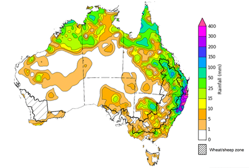
In the week ending 12 March 2025, Tropical Cyclone (TC) Alfred and low-pressure systems brought rainfall to eastern and northern Australia. High-pressure systems kept much of central western and central Australia largely dry.
- Parts of the northern tropics, including the far north of the Northern Territory and northern Western Australia, recorded rainfall totals of between 5-100 millimetres. In northern Queensland, up to 150 millimetres of rainfall fell in isolated areas.
- Ex-tropical Cyclone (TC) Cyclone Alfred brought rainfall totals exceeding 400 millimetres across parts of the east coast, including northern New South Wales and southern Queensland.
- Major to moderate flooding is occurring across numerous catchments in the affected region however conditions are easing. Reports indicated that horticulture, poultry, dairy and sugar cane have been affected, with growers facing damage to crops and farm infrastructure. Once flood waters begin to recede, we will get a better understanding of the impacts on production losses.
- Some inland area across south-eastern Australia recorded between 5-100 millimetres of rainfall over the period. Rainfall totals were generally low in remaining areas of Australia.
Rainfall totals were generally low across cropping regions.
- In Western Australia and South Australia, little to no rainfall was recorded. In Victoria, between 5-15 millimetres of rainfall was observed.
- In summer cropping regions, rainfall totals were generally high, with much of Queensland seeing between 5-150 millimetres of rainfall. North-eastern New South Wales saw between 5-100 millimetres of rainfall, with southern regions seeing lower rainfall totals of between 5-25 millimetres. This is expected to see an improvement in stored soil moisture but has likely interrupted the harvesting of some summer crops.
Rainfall for the week ending 12 March 2025
Note: The rainfall analyses and associated maps utilise data contained in the Bureau of Meteorology climate database, the Australian Data Archive for Meteorology (ADAM). The analyses are initially produced automatically from real-time data with limited quality control. They are intended to provide a general overview of rainfall across Australia as quickly as possible after the observations are received. For further information go to http://www.bom.gov.au/climate/rainfall/
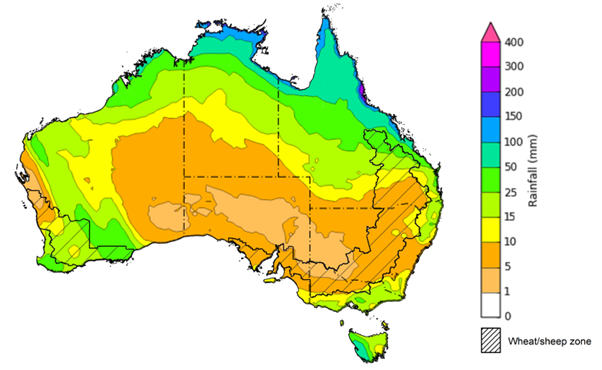
Over the 8 days to 20 March 2025, tropical lows and low-pressure troughs are expected to bring significant rainfall totals to parts of the north, west and far southeast of the country.
- Falls of between 50–150 millimetres are likely for the north of the Northern Territory and much of Queensland.
- In Western Australia, rainfall totals of 15-100 millimetres are expected in the north, while the south and west are likely to see 5-50 millimetres.
- Parts of north-eastern and south-eastern New South Wales, southern Victoria and Tasmania are likely to receive between 10-100 millimetres.
- High-pressure systems are expected to keep much of southern and central Australia relatively dry.
Rainfall totals across cropping regions over the coming week are forecast to be highly variable.
- Rainfall totals of between 10-50 millimetres are forecast for cropping regions in northern Queensland and Western Australia. If realised, these falls are likely to boost soil moisture for late planted summer crops and ahead of the planting of winter crops, however, this may bring some delays to the harvesting of earlier planted summer crops.
- In contrast, cropping regions in South Australia, Victoria, New South Wales, and southern Queensland are forecast to receive little to no rainfall over the period.
Total forecast rainfall for the period 13 March to 20 March 2025
Note: This rainfall forecast is produced from computer models. As the model outputs are not altered by weather forecasters, it is important to check local forecasts and warnings issued by the Bureau of Meteorology.
The El Niño Southern Oscillation (ENSO), Southern Annular Mode (SAM), and Indian Ocean Dipole (IOD) climate drivers are currently neutral and having minimal influence on Australian rainfall. The IOD is likely to remain neutral over the coming months. Additionally, the ENSO is likely to remain neutral until July, suggesting climate drivers will have little impact on Australian rainfall over the coming months.
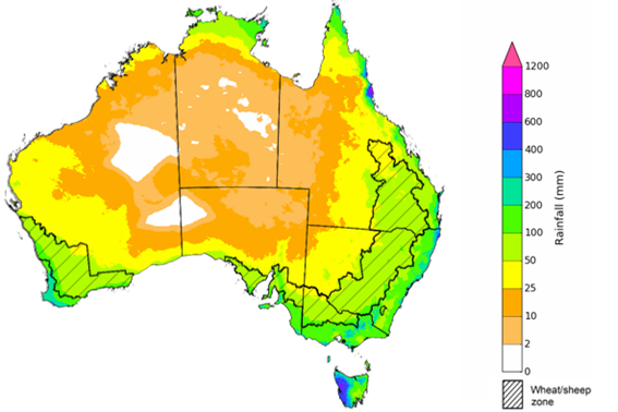
The most recent rainfall outlook for April 2025 provided by the Bureau of Meteorology indicates that much of northern Australia, and parts of the west, are likely to see above median rainfall. For the remaining regions, rainfall is expected to be close to average for the period. The Bureau of Meteorology’s climate model predicts a 75% chance of March rainfall totals between 25–200 millimetres across much of the northern Australia, with parts of far-north Queensland likely to see rainfall totals of above 300 millimetres.
- The Bureau of Meteorology’s climate model indicate a 75% chance of April rainfall totals between 10-200 millimetres across parts of the far-north, including the Northern Territory, with exceptions in the far-north of Western Australia were between 10-25 millimetres is likely. Parts of northern Queensland are expected to see as much as 400 millimetres.
- Eastern Australia, including southeast Queensland, eastern New South Wales, southern Victoria and Tasmania are likely to see between 10-100 millimetres of rainfall.
- Lower rainfall totals are expected across western, central and southern areas, with much of Western Australia, Northern Territory, South Australia, western Queensland and western New South Wales likely to see little to no rainfall.
- Across cropping regions, there is a 75% chance of rainfall totals of between 5-25 millimetres across most cropping regions. If realised, these rainfall totals would be considered below average for this time of year. A lack of sufficient rainfall in April is likely to result in an increased disconnect between upper- and lower-layer soil moisture. This meaning that there may be limited opportunities to plant winter crops under ideal conditions, particularly in some southern growing regions.
Rainfall totals that have a 75% chance of occurring in April 2025
![Map showing the rainfall totals that have a 75% chance of occurring during the next month in Australia. Image provided by the Bureau of Meteorology. Please refer to accompanying text for a more detailed description. For further information, go to http://www.bom.gov.au/climate/ahead/about/.]](/sites/default/files/images/Monthrainfallchance-130325.png)
The rainfall outlook for April to June 2025 indicates an increased probability of above average rainfall across parts of northern, eastern, and southern Australia. In contrast, much of the west of the country is showing an increased likelihood of receiving below median rainfall.
Across cropping regions, the chance of receiving above median rainfall is between 55–70% across much of South Australia and western Victoria, with Queensland having a 55–65% chance of above median rainfall. In Western Australia and New South Wales, the chances of receiving above or below median rainfall are approximately equal.
Chance of exceeding the median rainfall April 2025 to June 2025
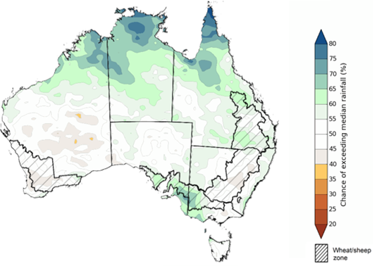
Issued: 13/3/2025
The rainfall outlook for April through to June 2025 suggests a 75% chance of receiving rainfall totals of between 10–200 millimetres across northern Queensland and the Northern Territory, with rainfall greater than 600 millimetres expected in far-north Queensland. Between 25–200 millimetres of rainfall are forecast across much of southern Queensland, New South Wales, South Australia, southern Western Australia, Victoria and Tasmania, with rainfall totals exceeding 200 millimetres likely across coastal and alpine areas. In central Australia, little to no rainfall is forecast over the period.
In cropping regions, there is a 75% chance of receiving between 25-100 millimetres. If realised, these forecast rainfall totals are likely to be sufficient to support autumn pasture growth across most of Australia. Additionally, these expected falls are likely to be sufficient to maintain above yield expectation for summer crops in Queensland and northern New South Wales and provide a boost to soil moisture profiles prior to the planting of winter crops during late autumn.
Water
Water storages, water markets and water allocations - current week
The Tableau dashboard may not meet accessibility requirements. For information about the contents of these dashboards contact ABARES.

Commodities
Information on weekly price changes in agricultural commodities is now available at the Weekly commodity price update.