Key issues
- In the week ending 10 July 2024, cold fronts and low-pressure troughs brought widespread rainfall to the southern half of Australia.
- Across cropping regions, rainfall totals between 10 and 50 millimetres were recorded in parts of southern Queensland, northern and central New South Wales, and western South Australia. In Western Australia, rainfall totals ranged between 100 millimetres on the west coast and 10 millimetres in the east. Across the south-east of Australia, rainfall was considerably lower.
- Over coming days, little to no rainfall is expected across much of the country.
- Across cropping regions, little to no rainfall is expected in the east, with falls of between 5 and 15 millimetres expected for much of South Australia and Victoria, and parts of southern New South Wales. Meanwhile, Western Australia is likely to see falls of between 5 and 25 millimetres.
- If realised, this rainfall is expected to support winter crop growth across much of southern Australia but will likely see a decline in soil moisture across cropping regions in New South Wales and Queensland.
- The national rainfall outlook for August to October is a high probability of above median rainfall across interior and eastern areas of the country.
- Across most cropping regions, the probability of exceeding median rainfall is between 45% and 70%.
- There is at least a 75% chance of receiving between 50 and 200 millimetres of rainfall. If realised, these expected rainfall totals will likely be sufficient in maintaining above average winter crops yields.
- Water storage levels in the Murray-Darling Basin (MDB) increased between 04 July 2024 and 11 July 2024 by 38 gigalitres (GL). The current volume of water held in storage is 17 307 GL, equivalent to 78% of total storage capacity. This is 17% or 3,564 GL less than at the same time last year. Water storage data is sourced from the BOM.
- Allocation prices in the Victorian Murray below the Barmah Choke decreased from $147 on 04 June 2024 to $134 on 11 July 2024. Prices are lower in the Murrumbidgee due to the binding of the Murrumbidgee export limit.
Climate
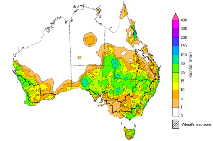
For the week ending 10 July 2024, cold fronts and low-pressure troughs brought widespread rainfall to the southern half of Australia. These weather systems combined to bring up to 100 millimetres of rainfall in isolated areas of Western Australia, South Australia, New South Wales, and southern Queensland. In Victoria and Tasmania, up to 50 millimetres of rainfall was recorded. In the northern tropics, a maximum of 200 millimetres of rainfall was observed in northeast coastal Queensland.
Across cropping regions, rainfall totals of between 10 and 50 millimetres were recorded in parts of southern Queensland, northern and central New South Wales and western South Australia. In Western Australia, rainfall totals ranged between 100 millimetres on the west coast and 10 millimetres in the east. Across the south-eastern Australia, rainfall totals were considerably lower, with much of southern New South Wales, Victoria and eastern South Australia recording between 5 and 15 millimetres. Recent rainfall has likely benefited the build-up of soil moisture across much of the wheat/sheep zone.
Rainfall for the week ending 10 July 2024
Issued: 10/07/2024
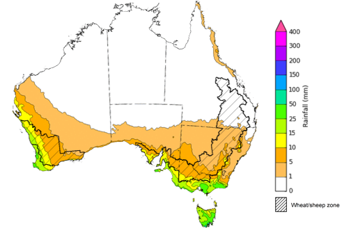
Over the 8 days to 18 July, little to no rainfall is expected much of the country, with parts of western and southern Australia being the main exceptions. Low-pressure systems in the south are expected to bring a maximum of 50 millimetres of rainfall across much of Tasmania, south Victoria, and isolated areas of far-west Western Australia. A maximum of 25 millimetres of rainfall is expected in southern South Australia. High-pressure systems in the north and central parts of the country are expected to keep the remainder of the country largely dry.
Across cropping regions, little to no rainfall is expected in the east, with falls of between 5 and 15 millimetres expected for much of South Australia and Victoria, and parts of southern New South Wales. Meanwhile, Western Australia is likely to see falls of between 5 and 25 millimetres. If realised, these rainfall totals are expected to support winter crop growth across much of southern Australia but will likely see a decline in soil moisture across cropping regions in New South Wales and Queensland.
Total forecast rainfall for the period 11 July to 18 July 2024
Issued 11/07/2024
Note: This rainfall forecast is produced from computer models. As the model outputs are not altered by weather forecasters, it is important to check local forecasts and warnings issued by the Bureau of Meteorology.
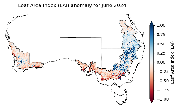
The Leaf Area Index (LAI) is a key indicator for assessing plant growth status and is a driving factor of net primary production. It represents the leaf area per unit of ground area and is measured both spatially and temporally. For example, a positive monthly LAI anomaly indicates a greener and denser canopy compared to the historical average, and vice versa. An LAI anomaly of zero indicates no divergence from the historical average. Monitoring LAI throughout the cropping season provides valuable insights into ongoing crop growth dynamics. The current analysis computes the anomalies for June 2024 against the historical June average.
In June 2024, positive (blue colours) LAI anomalies were detected across large areas of New South Wales and Queensland, and in central area of Western Australia cropping regions. This indicates flush growth of the crops with denser canopy associated with recent rainfall compared to the historical average of the month of June. The negative (red colours) LAI anomalies in remaining cropping regions indicates poorer growth and crop establishment compared to the historical average; reflecting the very low rainfall totals received during autumn 2024 in these areas.
Leaf Area Index (LAI) anomaly for June 2024
Note: The MCD15A2H Version 6.1 Moderate Resolution Imaging Spectroradiometer (MODIS) Level 4, Combined Fraction of Photosynthetically Active Radiation (FPAR), and Leaf Area Index (LAI) product is an 8-day composite dataset with 500 meter pixel size. The algorithm chooses the best pixel available from all the acquisitions of both MODIS sensors located on NASA’s Terra and Aqua satellites from within the 8-day period.
The most recent rainfall outlook for August 2024 provided by the Bureau of Meteorology indicates an increased likelihood of above median rainfall across the much of Australia. There is an increased likelihood of below median rainfall across parts of northern Australia and the southeast coast.
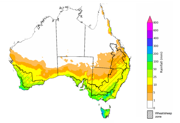
According to Bureau of Meteorology’s climate model, for August 2024 there is a 75% probability of rainfall totals between 10 and 100 millimetres across New South Wales, Victoria, Tasmania, southern South Australia and Western Australia. Southern Queensland is expected to receive up to 50 millimetres of rainfall. Alpine areas in New South Wales, Victoria, and the far west of Western Australia will likely receive rainfall of up to 200 millimetres. Tasmania is expected to receive up to 300 millimetres of rainfall. The northern areas of the country are expected to remain largely dry, typical of this time of year, with exceptions in parts of the tropical northeast Queensland where up to 50 millimetres of rainfall is expected.
Across cropping regions, there is a 75% chance of receiving between 10 and 50 millimetres of rainfall in New South Wales, Victoria, South Australia and Western Australia. In Queensland, rainfall totals of between 5 and 25 millimetres are expected across southern cropping regions, while little to no rainfall is expected for northern cropping regions. If realised, these rainfall totals are likely to be sufficient to support growth of winter crops across most cropping regions. In Queensland cropping regions, crop growth is expected to be supported by a drawdown of stored soil moisture.
Rainfall totals that have a 75% chance of occurring in August 2024
Issued: 11/07/2024
The El Niño Southern Oscillation (ENSO) and Indian Ocean Dipole (IOD) climate drivers are currently neutral and having minimal influence on Australian rainfall.
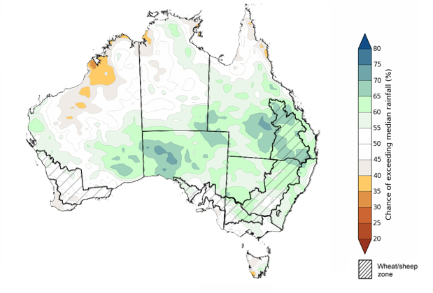
The rainfall outlook for August through October 2024 indicates that above median rainfall is more likely across interior and eastern areas of the country. In contrast, parts of northern Australia are expected to receive below median rainfall, with the probability of receiving median rainfall falling below 40% in isolated areas. Remaining areas have equal chance of receiving above or below median rainfall.
Across cropping regions, the probability of receiving median rainfall is between 45% and 70% in Queensland, New South Wales and Victoria. There is an equal chance of either above or below median rainfall in South Australian and Western Australian cropping regions. If realised, this rainfall would support ABARES forecasts of above average winter crop yields.
Chance of exceeding the median rainfall August to October 2024
Issued: 11/07/2024
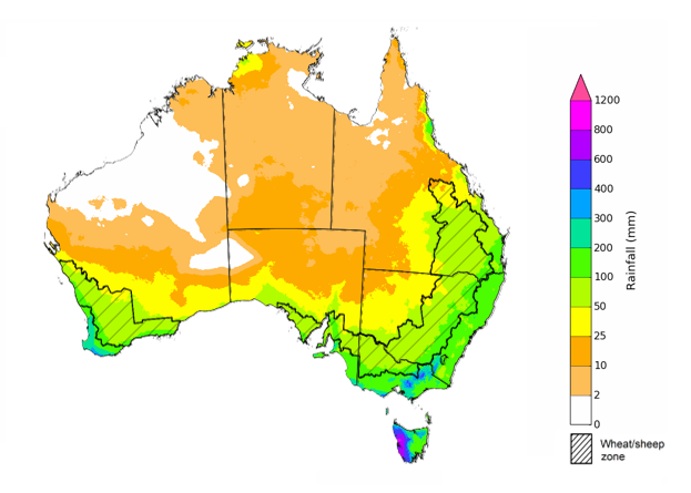
The outlook for August through to October suggests a 75% chance of rainfall totals between 25 and 200 millimetres occurring in the southern part of the country, with heaver rainfall of up to 600 millimetres forecast for isolated areas of far southwest Western Australia, alpine regions of Victoria and New South Wales, and western Tasmania. In Queensland, falls of between 25 and 100 millimetres are expected in the southeast and parts of the northeast, with coastal areas likely to receive up to 200 millimetres of rainfall. Much of the remainder of the country is expected to receive little to no rainfall, typical of this time of the year.
In cropping regions, there is at least a 75% chance of receiving between 50 and 200 millimetres of rainfall across much of New South Wales, Victoria, South Australia and Western Australia. In Queensland, falls of between 25 and 100 millimetres are expected, with drier conditions forecast for far northern cropping regions.
Expected rainfall is likely to be sufficient to support growth of winter crops, boost soil moisture profile and assist in maintaining above average winter crops yields.
Livestock producers, especially those in the south, are expected to experience close to average pasture production on the back of the improving rainfall outlook over the August to October period.
Rainfall totals that have a 75% chance of occurring August to October 2024
Issued: 11/07/2024
Water
Water storages, water markets and water allocations - current week
The Tableau dashboard may not meet accessibility requirements. For information about the contents of these dashboards contact ABARES.
Commodities
Information on weekly price changes in agricultural commodities is now available at the Weekly commodity price update.
