Key issues
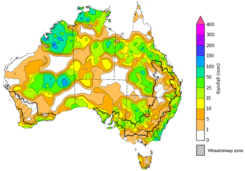
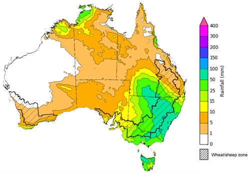
- For the week ending 5 October 2022, low-pressure systems and troughs brought rainfall scattered across parts of Australia. Weekly rainfall totals exceeding 50 millimetres were recorded in parts of south-eastern and western New South Wales, northern and western Queensland, eastern Victoria, the east and north of Western Australia and the north of the Northern Territory. High-pressure systems over southern parts of the country resulted in clear, dry conditions in some areas.
- Limited rainfall across New South Wales and Queensland cropping regions would have been a welcome change to the well above average rainfall received throughout September. The dry conditions this week would have seen some easing in localised flooding. However, soil profiles remain saturated and more dry weather will be required over the coming weeks to allow field access. The dry conditions have also allowed harvesting of winter crops to continue in Central Queensland, as well as the sowing of long-season summer crops.
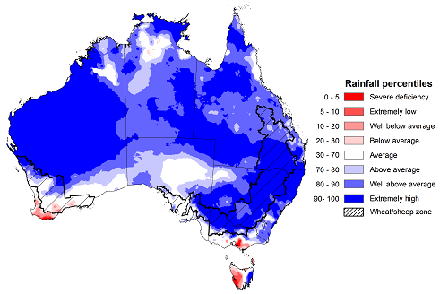
- Rainfall during September 2022 was the fifth highest September on record for Australia as a whole. Rainfall was above average to extremely high for much of Australia. However, rainfall was extremely low to below average for isolated parts of southern Victoria, the south-west of Western Australia, as well as parts of western and northern Tasmania.
- The rainfall through September has contributed to extremely high upper layer soil moisture for this time of year across much of New South Wales and Queensland, as well as northern Victoria, eastern Tasmania and large areas of South Australia, Western Australia and the Northern Territory (see Section 1.3). In addition, modelled pasture growth was above average to extremely high across large areas of New South Wales, Victoria, eastern Queensland, parts of southern South Australia and the west of Western Australia.
- Over the 8-days to 13 October 2022, low-pressure systems, frontal systems, and troughs are forecast to result in showers and storms across south-eastern Australia. High-pressure systems will provide clear, dry conditions across remaining parts of the country. Limited rainfall in parts of Central Queensland over the coming week will allow the harvest of winter crops and the sowing of long-season summer crops to gather pace. Significant rainfall across remaining cropping regions of south-eastern Australia will contribute to ongoing waterlogging across low-lying areas.
- Water storage in the Murray–Darling Basin (MDB) decreased by 161 gigalitres (GL) between 28 September 2022 and 5 October 2022. The current volume of water held in storage is 23,752 GL, which represents 94% of total capacity. This is 8% or 1,682 GL more than at the same time last year.
- Allocation prices in the Victorian Murray below the Barmah Choke increased from $45 per ML on 23 September to $51 per ML on 30 September 2022. Prices are lower in the Goulburn-Broken and regions above the Barmah choke due to the binding of the Goulburn intervalley trade limit and the Barmah choke trade constraint.
Climate
For the week ending 5 October 2022, low-pressure systems and troughs brought rainfall scattered across parts of Australia. Weekly rainfall totals exceeding 50 millimetres were recorded in parts of south-eastern and western New South Wales, northern and western Queensland, eastern Victoria, the east and north of Western Australia and the north of the Northern Territory. High-pressure systems over southern parts of the country resulted in clear, dry conditions in some areas.
In Australian cropping regions, rainfall totals of between 10 and 50 millimetres were recorded in parts of south-western and north-eastern New South Wales, south-eastern Queensland, north-western Victoria, much of South Australia and parts of the south-east of Western Australia. Little to no rainfall was recorded in remaining cropping regions of New South Wales, Queensland, Victoria and Western Australia for the week ending 5 October 2022.
Limited rainfall across New South Wales and Queensland cropping regions would have been a welcome change to the well above average rainfall received throughout September. The dry conditions this week would have seen some localised flooding ease. However, soil profiles remain saturated and more dry weather will be required over the coming weeks to allow field access. For winter crops planted in a timely manner and not subject to waterlogging, yield prospects remain very strong. The biggest challenge for growers will be receiving sufficiently dry conditions for winter crops to mature and harvesting to proceed.
The dry conditions have also allowed harvesting of winter crops to continue in Central Queensland, as well as the sowing of long-season summer crops. A continuation of dry conditions in Western Australia are proving favourable for winter crops there, while wet conditions in remaining parts of eastern Australia are expected to delay the start of harvesting of winter crops.
Rainfall for the week ending 5 October 2022
Note: The rainfall analyses and associated maps utilise data contained in the Bureau of Meteorology climate database, the Australian Data Archive for Meteorology (ADAM). The analyses are initially produced automatically from real-time data with limited quality control. They are intended to provide a general overview of rainfall across Australia as quickly as possible after the observations are received. For further information go to http://www.bom.gov.au/climate/rainfall/
Rainfall during September 2022 was the fifth highest September on record for Australia as a whole. Rainfall was above average to extremely high for much of Australia. However, rainfall was extremely low to below average for isolated parts of southern Victoria, the south-west of Western Australia, as well as parts of western and northern Tasmania.
The main climate influences for September were a negative Indian Ocean Dipole (IOD), a positive Southern Annular Mode (SAM) and the establishment of a La Niña event in the Pacific Ocean. A negative IOD typically results in enhanced rainfall in a broad band extending from the north-west to the south-east of Australia. A positive SAM is associated with increased rainfall across parts of eastern Australia but less rainfall for parts of southern Australia. La Niña events tend to increase rainfall across eastern, central and northern Australia.
September 2022 rainfall was well above average to extremely high across cropping regions of New South Wales, Queensland, much of Victoria, eastern parts of South Australia and northern parts of Western Australia. September rainfall was below average for southern parts of Western Australia but generally average for all remaining cropping regions.
Extremely high rainfall across eastern Australia in September followed a wet start to the winter cropping season and well above average rainfall across New South Wales, and parts of central Victoria and the north of Western Australia in August 2022. The wet conditions have exacerbated waterlogging in low lying areas, negatively impacting winter crop development. Yield potentials remain very favourable for crops not impacted by waterlogging. However, field access has continued to be limited and the wet conditions have contributed to increases in fungal disease pressure. Harvesting of winter crops in Central Queensland has started in recent weeks and will continue south if conditions allow. However, wet conditions have delayed harvest windows across eastern Australia cropping regions.
Rainfall percentiles for September 2022
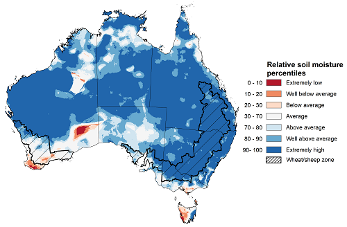
Upper layer soil moisture in September 2022 was extremely high for this time of year across much of New South Wales and Queensland, as well as northern Victoria, eastern Tasmania and large areas of South Australia, Western Australia and the Northern Territory reflecting high monthly rainfall in these areas. Extremely low upper layer soil moisture was evident across isolated parts of southern Victoria, the east and south-west of Western Australia, and central and western Tasmania. Modelled upper layer soil moisture was generally average to above average across the remainder of the country.
At this time of year, upper layer soil moisture impacts the ability of growers to access paddocks. For growers across southern Australia, management of fungal disease pressure due to the wet conditions as well as fertiliser top dressing as we approach grain filling will be an ongoing concern. For growers in Central Queensland, upper layer soil moisture may impact the harvesting of winter crops and the planting of some summer crops in low lying areas. However, upper layer soil moisture will be critical for supporting the germination and establishment of summer crops.
Upper layer soil moisture was extremely high for this time of year across cropping regions in New South Wales, Queensland, Victoria, the east of South Australia and northern Western Australia. Upper layer soil moisture was average to above average for remaining cropping regions of South Australia and Western Australia, except for isolated parts in the south of Western Australia where upper layer soil moisture was below average. Extremely high upper layer soil moisture across cropping regions of eastern Australia has prevented field access. However, field access will have improved for some part of South Australia and Western Australia since August.
Modelled upper layer soil moisture for September 2022
Source: Bureau of Meteorology (Australian Water Resources Assessment Landscape model)
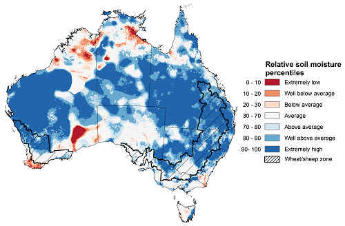
Lower layer soil moisture for September 2022 was well above average to extremely high for this time of year across large parts of New South Wales and Queensland, north-western Victoria, scattered parts of South Australia, western and central parts of Western Australia, the south and north of the Northern Territory, as well as eastern Tasmania. Lower layer soil moisture was well below average to below average in isolated parts of south-eastern New South Wales, north-western Queensland, the east of Victoria, scattered part of the south and north of Western Australia, as well as parts of the north of the Northern Territory and western Tasmania. Modelled lower layer soil moisture was generally average across the remainder of the country.
Lower layer soil moisture will be important for winter crops as they enter flowering and grain filling over the coming weeks and help support what is expected to be a very large spring and summer crop planting season and peak pasture growth period.
In cropping regions, lower layer soil moisture was well above average to extremely high across central and northern New South Wales, much of Queensland, north-western Victoria, the east of South Australia, as well as central and northern Western Australia. Lower layer soil moisture was generally average across remaining areas of New South Wales, Victoria, South Australia, as well as southern areas of Western Australia.
Well above average to extremely high lower layer soil moisture levels across central and northern New South Wales as well as Queensland present a potential downside risk to yields. These areas are subject to increased chances of exceeding median rainfall over the next three months, increasing the potential of ongoing saturated soils and waterlogging and reducing potential yields. However, it does provide a reserve of plant available water for summer crops later in the growing season. Average or better soil moisture levels in most cropping regions across southern Australia will support winter crop yield potentials as crops draw on lower layer soil moisture during grain filling over the coming weeks. Likewise, pasture growth is expected to remain strong given current plant available water.
Modelled lower layer soil moisture for September 2022
Source: Bureau of Meteorology (Australian Water Resources Assessment Landscape model)
Pasture growth during the July to September period is typically low across large areas of central and northern Australia as it is firmly in the dry season. Across southern Australia, July to September pasture growth influences the number of livestock than can be supported without supplementary feeding over winter and the level of reliance on hay and grain to boost livestock production with the onset of spring.
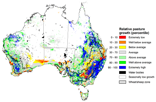
For the 3 months to September 2022 above average rainfall totals and mild temperatures resulted in well above average pasture production for this time of year across most grazing regions.
Modelled pasture growth was above average to extremely high across large areas of New South Wales, Victoria, eastern Queensland, parts of southern South Australia and the west of Western Australia. This growth is likely to enable farmers to continue to rebuild stock numbers and provide opportunities to replenish fodder supplies during spring. In contrast, modelled pasture growth was extremely low to below average across scattered areas of New South Wales, parts of southern Queensland, central South Australia, and central Western Australia.
Relative pasture growth for 3-months ending September 2022 (1 July to 30 September 2022)
Source: Queensland Department of Science, Information Technology and Innovation
Over the 8-days to 13 October 2022, low-pressure systems, frontal systems, and troughs are forecast to result in showers and storms across south-eastern Australia. High-pressure systems will provide clear, dry conditions across remaining parts of the country.
In Australian cropping regions, rainfall totals of between 10 and 50 millimetres are expected across New South Wales, Victoria, eastern and central South Australia, and south-western Queensland. Rainfall in excess of the of the monthly median for October are forecast for large areas of central and northern New South Wales. Little to no rainfall is forecast for remaining cropping regions in northern Queensland and Western Australia during the next 8-days.
Limited rainfall in parts of Central Queensland over the coming week will allow the harvest of winter crops and the sowing of long-season summer crops to gather pace. Significant rainfall across remaining cropping regions of south-eastern Australia will contribute to ongoing issues of waterlogging across low-lying areas. These wet conditions are expected to prolong inundation of crops, negatively impacting yield potentials, as well as restricting the ability to access fields for disease management. Yield potentials remain above average across cropping regions, but rainfall over the coming weeks is unlikely to improve them further.
The biggest threat to yield potentials across eastern and southern cropping regions remain waterlogging and frost as winter crops enter flowering and grain filling. For Western Australia, a late frost presents the biggest downside risk, given the very favourable growing conditions to date. The continued influence of a negative Indian Ocean Dipole and the establishment of a La Niña event in the Pacific Ocean suggests a continuation of wet conditions over the coming months for eastern Australia. A likely consequence will be delays in harvesting winter crops and planting summer crops, as well as increased crop damage.
Total forecast rainfall (mm) for the period 6 October to 13 October 2022
Issued 6/10/2022 Note: This rainfall forecast is produced from computer models. As the model outputs are not altered by weather forecasters, it is important to check local forecasts and warnings issued by the Bureau of Meteorology.
Water
Water storages, water markets and water allocations - current week
The Tableau dashboard may not meet accessibility requirements. For information about the contents of these dashboards contact ABARES.
Commodities
Information on weekly price changes in agricultural commodities is now available at the Weekly commodity price update.

