Key issues
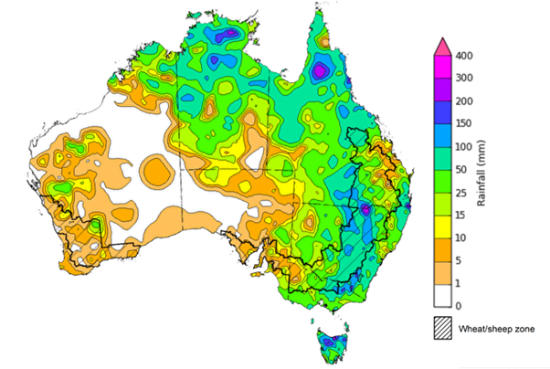
- In the week ending 4 December 2024, low-pressure systems brought rainfall to much of northern and eastern Australia.
- Many cropping regions across eastern Australia recorded significant rainfall. Totals of between 10 to 100 millimetres were recorded across large parts of Victoria, New South Wales and Queensland, with isolated areas seeing rainfall as high as 300 millimetres.
- Cropping regions in South Australia and Western Australia were drier, generally receiving 0 to 10 millimetres of rainfall.
- For eastern areas that recorded significant rainfall this week, this has likely delayed the harvest of remaining winter crops.
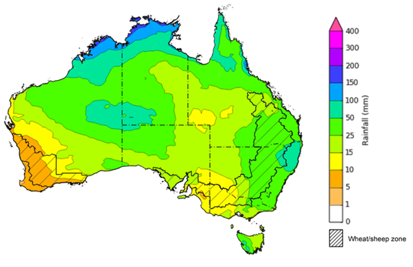
- Over coming days, low-pressure systems are expected to bring showers over parts of northern, central and eastern Australia. High-pressure systems are expected to keep remaining areas largely dry.
- Over the coming days, low-pressure systems are expected to bring rainfall across all states and territories.
- Across cropping regions, rainfall is expected to be high in the east, with falls of between 15 and 50 millimetres forecast across much of Queensland, and 10 and 100 millimetres in New South Wales. Meanwhile, falls of between 10 and 25 millimetres are forecast for much of South Australia and Victoria. Western Australia is likely to see between 5 and 15 millimetres.
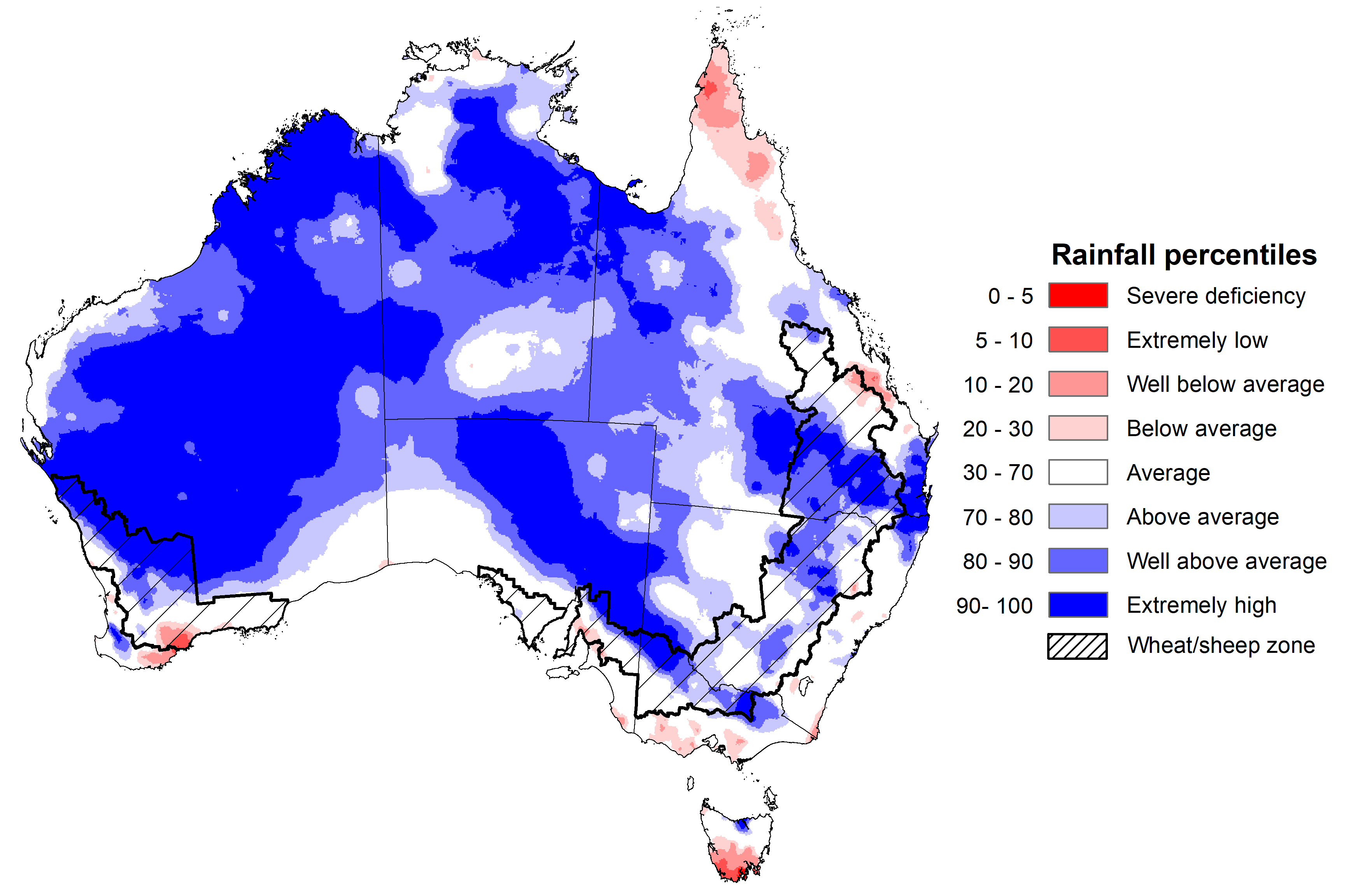
- Nationally, November rainfall was well above average across much of the country, with parts of the far-north and far-south seeing below average rainfall.
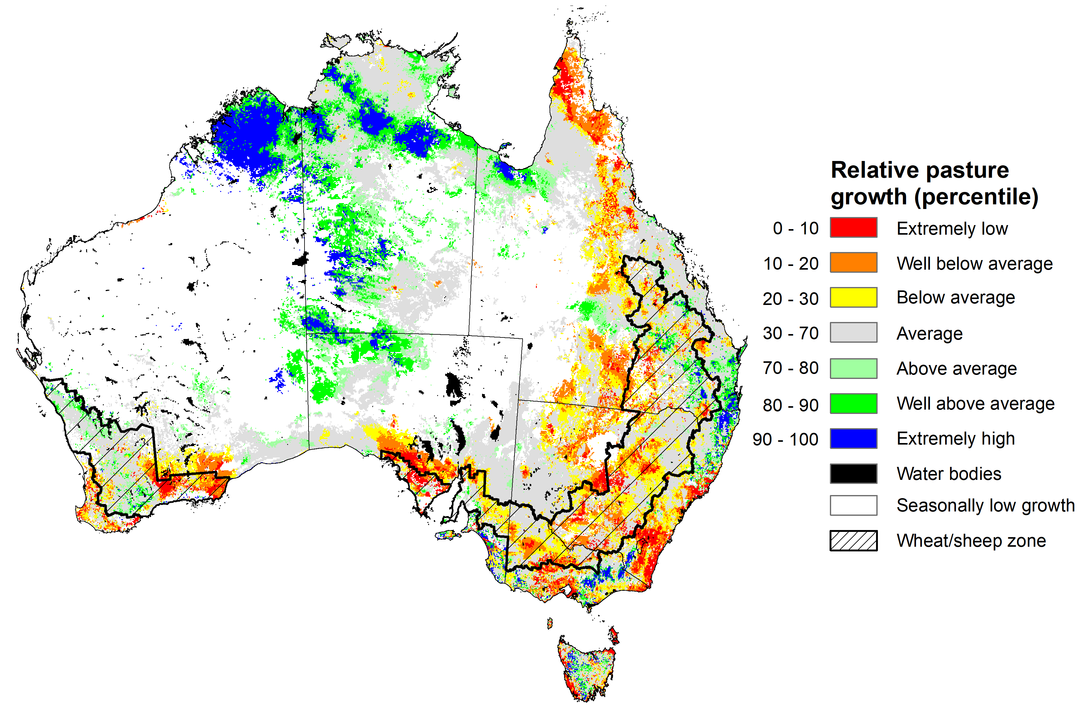
- For the 3 months to November 2024, above average rainfall totals resulted in average to extremely high pasture production across large parts of northern Australia. Below average to extremely low pasture growth was recorded across large areas of eastern and southern Australia.
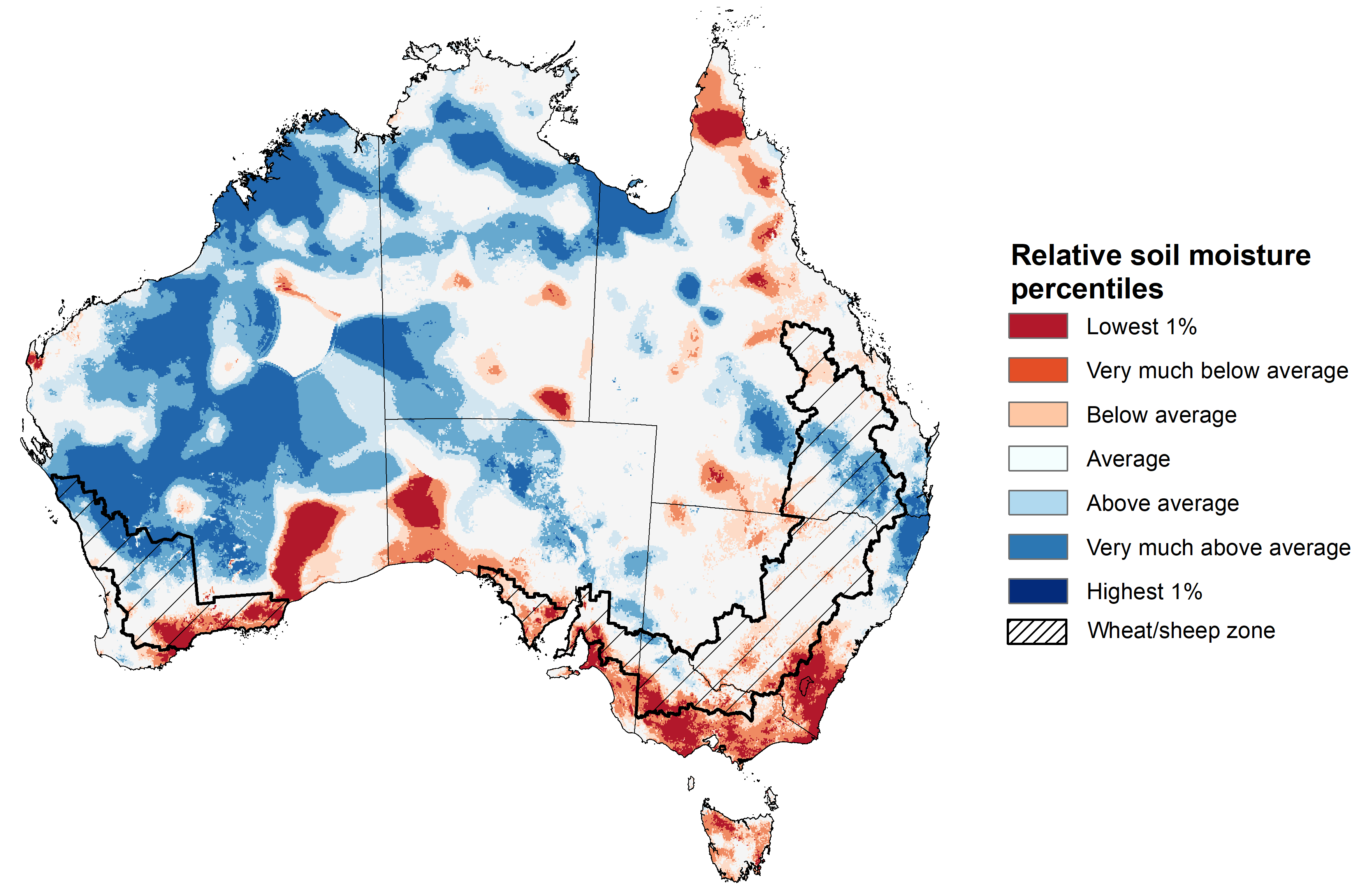
- Soil moisture models continue to indicate low soil moisture levels in southern Australia, with above average soil moisture modelled in eastern Queensland, northern New South Wales, and large parts of Western Australia and the Northern Territory
- Water storage levels in the Murray-Darling Basin (MDB) increased between 28 November 2024 and 5 December 2024 by 106 gigalitres (GL). Current volume of water held in storage is 16 304 GL, equivalent to 73% of total storage capacity. This is 17 percent or 3,425GL less than at the same time last year. Water storage data is sourced from the Bureau of Meteorology.
- Allocation prices in the Victorian Murray below the Barmah Choke decreased from $136 on 28 November 2024 to $119 on 5 December 2024. Prices are lower in regions above the Barmah choke due to the binding of the Barmah choke trade constraint.
Climate
In the week ending 4 December 2024, low pressure systems and an embedded cloud band brought rainfall and storms to the east and north of the country. Falls of between 10 and 100 millimetres were recorded across much of New South Wales, Queensland, Victoria, Tasmania, the Northern Territory as well as parts of eastern South Australia and northern and central Western Australia. Meanwhile, storm activity brought falls in excess of 100 millimetres to isolated areas of the Northern Territory, Queensland, New South Wales, eastern Victoria and northern Tasmania. In contrasts, high-pressure systems kept much of the remainder of South Australia and Western Australia relatively dry.
Across cropping regions, rainfall outcomes were mixed. In the east, rainfall totals were high, with much of Queensland and Victoria receiving between 10 and 100 millimetres, with New South Wales seeing between 15 and 150 millimetres. Rainfall totals were lower in remaining regions, with much of Western Australia receiving between 0 and 10 millimetres and South Australia receiving between 5 and 10 millimetres. For those south-eastern areas that recorded significant rainfall this week, this has likely delayed the harvest of remaining winter crops.
Rainfall for the week ending 4 December 2024
Over the 8 days to 12 December 2024, extensive low-pressure systems are expected to bring falls of between 10 and 100 millimetres are forecast for much of the country. Heavier fall of between 100 and 200 millimetres have been forecast for part of northern Queensland, northern Western Australia and the north of the Northern Territory. High-pressure systems are expected to keep the southwest of Western Australia relatively dry, with rainfall totals of between 5 and 10 millimetres forecast over the period.
Across cropping regions, rainfall totals are forecast to be high in the east, with lighter falls expected in the south and west. Much of Queensland and New South Wales are forecast to receive between 15 and 50 millimetres of rainfall, with parts of northern New South Wales likely to see up to 100 millimetres. In contrast, Western Australia is likely to see between 5 and 15 millimetres, with South Australia and Victoria forecast to receive between 10 and 25. Exceptions exist in far-east Victoria, with falls of up to 50 millimetres forecast. If realised, rainfall across eastern cropping regions will likely interrupt the harvest of remaining winter crops. Rainfall forecast for summer cropping regions in northern New South Wales and Queensland will likely provide a boost for soil moisture levels and support the germination and growth of crops already in the ground.
Total forecast rainfall for the period 5 December to 12 December 2024
During November 2024, rainfall was well above average to extremely high across much of the country, with much of Western Australia, the Northern Territory, northern and central South Australia, southern and western Queensland, central New South Wales and northern Victoria all recording above average or higher rainfall over the period. In contrast, parts of northern Queensland, southern Victoria and Tasmania, and isolated areas of southern Western Australia saw below average to extremely low rainfall. The remainder of Australia saw generally average November rainfall.
In cropping regions, November 2024 rainfall was generally average to above average, with much southern Queensland, northern Western Australia, northern Victoria, large areas of New South Wales, and parts of northern South Australia seeing well above average rainfall. Areas that recorded below average rainfall were limited to scattered areas of northern Queensland, southern Western Australia and South Australia. Above average rainfall totals in Queensland and northern New South Wales are likely to support the build-up of soil moisture and benefit the sowing and establishment of summer crops. Meanwhile, above average rainfall across winter cropping regions is likely to have distributed harvest activities and may have resulted in some grain quality downgrades.
Rainfall percentiles for November 2024
Modelled upper layer soil moisture was generally average to above average across much of the country. Much of Western Australia, the Northern Territory, and South Australia saw very much above average soil moisture for the period, with the exception of some southern areas with below average soil moisture. Much of the east of the country saw close to average upper layer soil moisture for this year. In contrast, parts of Tasmania, southern Victoria, and northern Queensland were modelled with below average or very much below average upper layer soil moisture.
At this time of year, upper layer soil moisture is important at the beginning of the summer cropping season and for pasture growth across northern Australia since plant germination and establishment utilise this moisture. It is also an important indicator of the ability to access paddocks for winter crop harvesting and summer crop planting activities.
Across cropping regions, upper layer soil moisture in November was modelled to be generally average across much of Victoria, South Australia and New South Wales, as well as parts of northern Queensland. In Western Australia, upper layer soil moisture varied considerably between northern and southern cropping regions, with very much above average upper layer soil moisture modelled in the north, and very much below average in the south. While average to above average upper layer soil moisture in New South Wales and Queensland would have supported to growth and establishment of summer crops already in the ground, they are likely to have interrupted harvest completion and impeded access for the ongoing planting of summer crops.
Modelled upper layer soil moisture for November 2024
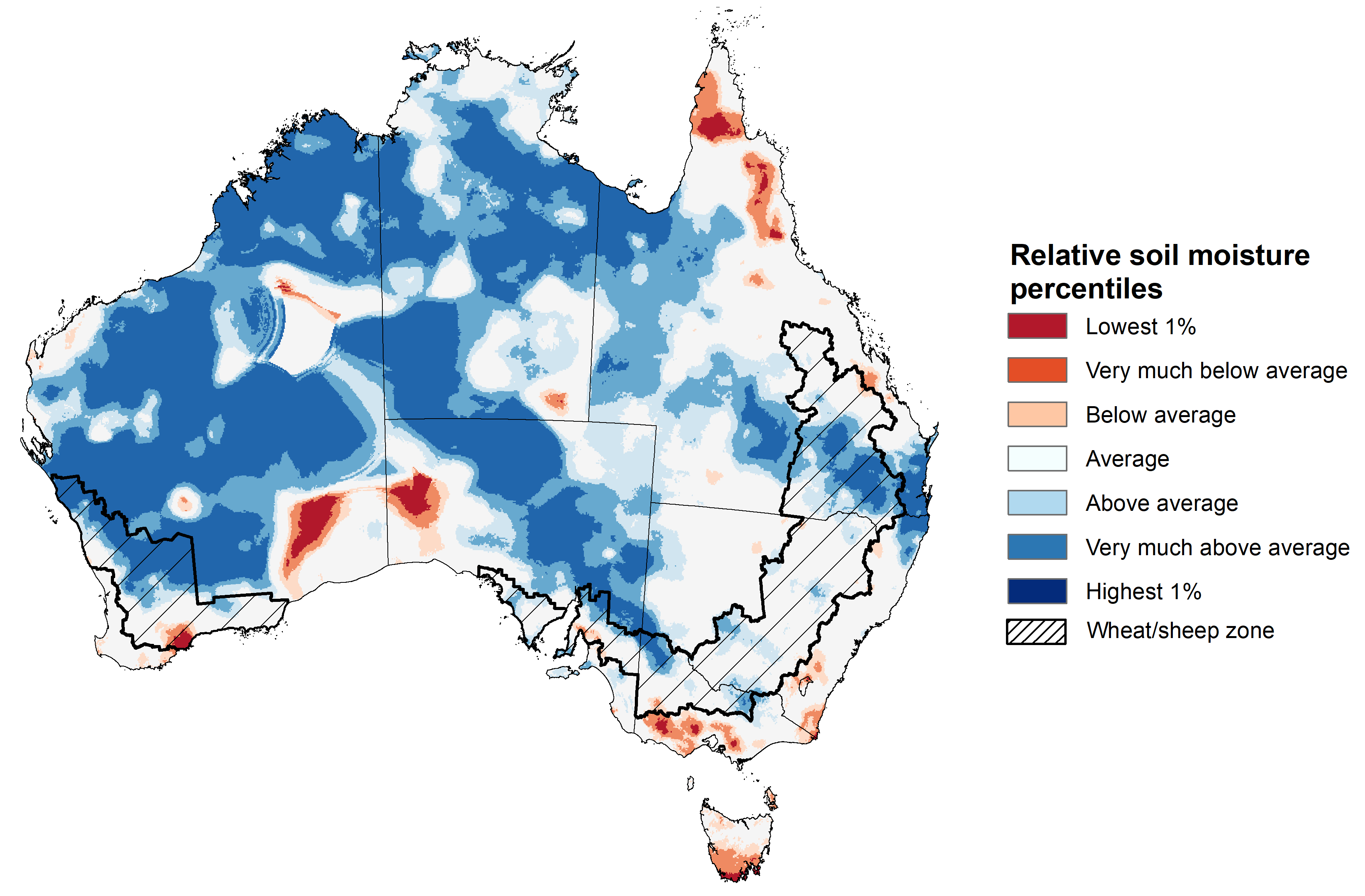
Across northern and central Australia, lower layer soil moisture was average to very much above average, with northern Western Australia, western Northern Territory and scattered parts of eastern Queensland seeing very high soil moisture levels for this time of year. In contrast, large areas of southern Australia and central Queensland were modelled to have extremely low to below average lower layer soil moisture.
Lower layer soil moisture plays a pivotal role in sustaining the growth of winter crops and pasture during their critical development stages.
Across cropping regions, lower layer soil moisture was generally average in Queensland and much of New South Wales, northern Victoria and eastern South Australia. In Western Australia, lower layer soil moisture varied between northern and southern cropping regions, with very much above average upper layer soil moisture modelled in the north, and very much below average in the south. In western South Australia, southern Victoria, and southern New South Wales, November lower layer soil moisture was modelled to be extremely low to below average for this time of year. Cropping regions in far southern Australia with extremely low levels of stored soil moisture will require sufficient and timely rainfall for the remainder of spring to arrest declining levels of crop and pasture production.
Modelled lower layer soil moisture for November 2024
Pasture growth during the September to November period is typically low across large areas of central and northern Australia as it is nearing the end of dry season. Across southern Australia, September to November is the peak pasture growth period which typically provides a bulk of feed and allows for fodder conservation to maintain production through the low pasture growth months of summer. It also influences the growth, branding and marking rates of lambs and calves, and the production of meat, milk, and wool over this peak production period.
For the 3 months to November 2024, average to extremely high pasture growth relative to this time of year was modelled across much of the northern and central Australia, including the Northern Territory, eastern Queensland, northern Western Australia and northern South Australia, Additionally, average to above average pasture grow was also observed in north-eastern New South Wales, south-eastern Queensland, and parts of eastern Victoria, central Tasmania and the southwest of Western Australia. This is likely to enable farmers to continue to maintain stock numbers and provide opportunities to build standing dry matter availability and replenish fodder supplies during late spring and early summer.
In contrast, large areas of eastern and southern Australia saw relatively low pasture growth for this time of year. Extremely low to below average to pasture growth was modelled across much of central and south-eastern New South Wales, Victoria, northern and central Queensland, southern South Australia and part of southern Western Australia. This has likely led to a decline in pasture availability and graziers in regions where below average pasture growth was recorded will be more reliant on supplemental feed to maintain current stocking rates and production.
Relative pasture growth for 3-months ending November 2024 (1 September to 30 November 2024)
Water
Water storages, water markets and water allocations - current week
The Tableau dashboard may not meet accessibility requirements. For information about the contents of these dashboards contact ABARES.
Commodities
Information on weekly price changes in agricultural commodities is now available at the Weekly commodity price update.
